Places worth discovering

Things to Do

Find attractions, experiences and places to visit. Events remain the best way to see what is happening on a particular date.

Looking for a dated event? Explore Events

14856 places

Explore local places

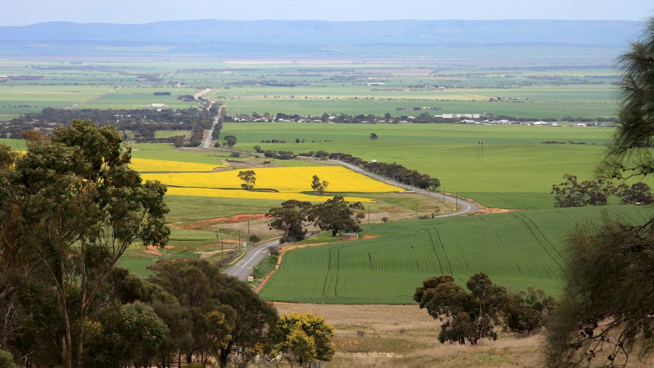
Brooks Lookout in Spring
Image credit: Ian Roberts

Landmarks and Buildings

Brooks Lookout

Brooks Lookout was opened in 2001 and gives visitors to the Clare Valley the opportunity to picnic at one of the big Australian panoramas. Sited 400 metres above the patchwork of wheat field's of the Blyth and Wakefield Plains, you can see 90 kilometres to the southwest to Yorke Peninsula. The township of Blyth sits at the base of the Clare Hills and the Barunga and Hummocks Ranges, which form a photographic backdrop to the west. The land on which the lookout is sited was donated by a private landowner, and includes two hectares of locally rare heath land vegetation with many plants labelled. A picnic table and shelter, interpretive signage and a large car park complete a not to be missed Clare Valley attraction. Please note the carpark is closed during fire season Nov-April, but you can still park on adjacent roadside and walk the extra 20 metres to Lookout.

Blyth SA

View place
Experience Queensland's number one public access golf course, Brookwater Golf and Country Club
Image credit: Brookwater Golf & Country Club

Sports and Recreation Facilities

Brookwater Golf and Country Club

Weave your way through two nine-hole loops and immerse yourself in the gorgeous natural surrounds of Brookwater Golf Course. Featuring undulating greens, natural water features, and long, narrow fairways, the course's strategic design makes it the perfect environment for golfers of any skill to enjoy a day of premium golf. Masterfully designed by Greg Norman, the award-winning public access golf course offers a golfing experience you won't easily forget. Before or after your round, enjoy a delicious lunch or dinner at the restaurant in their architecturally designed clubhouse. With beautiful views over the eighteenth hole and natural bush land, you won't want to leave in a hurry!

Brookwater QLD

View place
Broome Bird Observatory

Zoos, Sanctuaries, Aquariums and Wildlife Parks

Broome Bird Observatory

You can discover more than a third of Australia’s bird species, over 300, at Broome Bird Observatory, regarded as the hottest spot on the planet for viewing migratory shorebirds. The observatory is nestled on Roebuck Bay, a 35-minute drive east from Broome. Flights from Perth to Broome take two and a half hours, and transfers to the observatory are available from Broome when you book one of the guided tours, each showcasing a different habitat and its diverse birdlife. Spot up to 50 species on red-sand beaches on the Shorebirds Tour. Look out for the mangrove grey fantail and broad-billed flycatcher on the Mangrove Tour. See a host of freshwater shorebirds and birds of prey on the Lakes Tour. Discover a rich diversity of species on the ever-changing Bush and Plains Tour. Scan the samphire flats for one of Australia’s most elusive species on the Yellow Chat Twitch Tour, or hone your birding skills on one of the popular courses. Learn about the ecological importance of Roebuck Bay, and find out about the observatory’s vital research and conservation work. The observatory also offers a range of basic accommodation, including units, a cottage, and an un-powered campground with a bush kitchen.

Roebuck WA

View place
Broome Courthouse
Image credit: Tourism WA

Historical Sites and Heritage Locations

Broome Courthouse

Check out the distinctive Broome-style architecture and soak up the laid-back tropical ambience of the historic Broome Courthouse. Once a Cable Station which served the telephone cable from Broome to Perth and northwards through a submarine cable to Banji Wangi in the Dutch East Indies. A visit to the Broome Courthouse is an iconic Broome experience - enjoy a picnic under the beautiful old trees and admire the well-kept gardens or take a short stroll to Chinatown in the heart of Broome The Broome Courthouse Markets are held in the beautiful heritage-listed gardens of the Broome Courthouse from 8am every Saturday (all year) and Sunday (during high season - usually from April to October). The local markets attract visitors from far and wide and are a fantastic place to try a selection of cuisines, purchase from local sellers and creators, and browse the variety of stalls.

Broome WA

View place
Broome Gallery
Image credit: Broome Gallery

Galleries, Museums and Collections

Broome Gallery

Broome has an amazing history and the local museums and art galleries are the best place to discover more. The natural colours of the Kimberley have attracted many artists and photographers who have vibrant galleries in Broome. Broome Gallery is a contemporary gallery with a difference. Showcasing Kimberley Artist James Down with his vivid artworks, which utilise the amazing and brilliant Broome and Kimberley colours.

Broome WA

View place
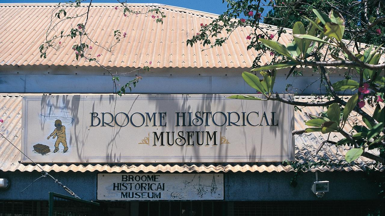
Signage at the Broome Historical Museum
Image credit: Tourism WA

Galleries, Museums and Collections

Broome Historical Society Museum

Broome Historical Society Museum offers an insightful look into Broome’s diverse cultural history. Take a walk through the charming 1890s former general store, which is now the town’s museum. Check out the well-presented visual displays, photographs and artefacts to learn all about the history of Broome. Find out about the town’s interesting pearling history which has developed into a world-class export industry today. Learn about the terrifying Japanese attacks on Broome during World War II and the impact they had on the local residents and allies who had taken refuge there. You will be intrigued by the tales of shipwrecks and missing diamonds which takes you on a journey of discovery into the development of a culture that has melded from a diversity of origins. Examine Aboriginal artefacts and memorabilia from the area and discover how the town of Broome became the first truly multicultural district in Australia. Regarded as one of the best regional museums in Australia, it is located in the town centre of Broome which is a two-and-a-half-hour flight north of Perth. Check opening hours prior to visiting. The Broome Historical Society has been committed to preserving and protecting Broome’s heritage and history for over forty years. Their significant collection is spread across three buildings, including the heritage award-winning Sailmaker’s Shed.

Broome WA

View place
Broome Town Beach
Image credit: Australia's North West

Natural Attractions

Broome Town Beach

Town Beach is located on the southeast edge of Broome, a few minute's drive from the centre of the historic pearling town and overlooks the stunning turquoise-coloured Roebuck Bay. Town Beach is a popular draw-card for holidaying families. Its' spectacular calm aqua water makes for perfect photo opportunities. The park and foreshore are the place to be for the 'Staircase to the Moon' and the Thursday evening markets, and it forms part of the 'Jetty to Jetty' walking trail. The Town Beach precinct is a beautiful space to explore after the 24-million-dollar redevelopment and the opening of the brand-new Town Beach Jetty. Come to the town beach to enjoy the water playground on a warm day with the kids and relax at the nearby café. Bring your picnic and spread out on the grass for an enjoyable day. Town Beach is also the starting point to walk across the mudflats on extremely low tides to see the Catalina Flying Boats Wrecks. These wrecks are heritage-protected and respected locally as a war gravesite. The Broome Visitor Centre can assist you with details on dates when it might be suitable to walk across to see these remarkably preserved flying boat wrecks. You will also find the Broome Pioneer Cemetery at Town Beach.

Broome WA

View place
Looking back to the stairs. Brooms Head Back Beach.
Image credit: My Clarence Valley

Natural Attractions

Brooms Head Back Beach

It's amazing how a few hundred metres and 90 degrees of rotation can change the look and feel of a coast, and nowhere on the Clarence Valley's beaches is this difference more striking than Brooms Head Back Beach, north coast NSW. Where the Main Beach is all ice creams and Holiday Park vibes, the Back Beach is more romantic and openly serene. Follow the path from the Brooms Head lookout as it leads down to a beach that feels like it could be miles from anywhere, when in fact it's a stone's throw from Brooms Head. Swimming-wise, extreme caution is advised. Unpatrolled waters can be unpredictable. Choose patrolled beaches (Brooms Head Main Beach, around the corner, is patrolled during the school holidays) for a safer experience and swim only between the flags. Avoid jumping into unknown water depths or areas with unseen hazards. Be aware of currents, rocks, and sudden drops, and always make sure you're swimming in safe areas to protect yourself and your loved ones!

Brooms Head NSW

View place
Holiday Park foreshore, Brooms Head.
Image credit: My Clarence Valley

Natural Attractions

Brooms Head Main Beach

Brooms Head Beach, northern NSW, is a stunning stretch of coastline where boulders have naturally formed a tidal pool, offering calmer waters between the rocks and the shore. It's a popular spot for visitors looking to paddle, play, and soak up the coastal vibes. Many memories have been made along this beachfront - melting ice creams, beachside barbecues, and the unmistakable scent of sunblock in the air. Main Beach is patrolled by lifeguards during the summer holidays, and beachside amenities make for an easy day by the water. As always, ocean conditions can change, so it's important to stay aware and swim with caution. On the northern side of the bridge, pets are welcome, making this a top spot for your four-legged friend.

Brooms Head NSW

View place
Brooms Head to Illaroo

Natural Attractions

Brooms Head to Illaroo

If you love beach hiking then the moderate Brooms Head to Illaroo section of Yuraygir coastal walk is for you. Take in sweeping stretches of golden beaches and protected woodlands of paperbarks. There are scenic coastal views at the southern end of Brooms Head Beach which are ideal for whale watching and dolphin spotting. At low tide, explore Plover Island, which holds great cultural significance for the Yaegl People. Middens and artefacts have been discovered in the area and information about these can be found on the island. Sandon River, around the halfway lunch break mark, is the northernmost point of Solitary Islands Marine Park, which runs south for 75 kilmetres to Muttonbird Island at Coffs Harbour. The small settlement of Sandon, on the south side of the river, is made up of only about 35 dwellings.

The Sandon NSW

View place
Brooweena, Fraser Coast

Historical Sites and Heritage Locations

Brooweena Historical Village and Museum

The Brooweena Historical Village is a charming village depicting what life was like in days gone by, set in a tranquil rural setting in the hamlet of Brooweena 304 kilometres north of Brisbane. Europeans first settled in this area in 1849, and the town developed with the arrival of the railway line in 1889. The local sawmill opened in 1924, and timber continues to be an important local industry today. Sugar production is also one of Woocoo Shire's major industries. A collection of 12 heritage buildings presents a mosaic of the past, during peace and war - early education, recreation, elegance, and gracious living are on display. There is a rustic barn with a collection of bullock and horse-drawn vehicles and an original settler's slab dwelling with a detached kitchen. Other buildings in the village well worth an inspection include a dairy shed, a blacksmith's shop, the original Woocoo Shire Office (which was constructed in the town), the former Brooweena railway station, a brake van, railway goods shed, a settler's slab hut and a butcher shop. The museum contains an extensive array of memorabilia, and musical instruments, including accordions, those indispensable items of bush dances in the past. The museum is open the second and fourth Sunday of the month from 10am - 3pm (other times by prior arrangement).

Maryborough QLD

View place
Brooweena War Memorial

Historical Sites and Heritage Locations

Brooweena War Memorial

Brooweena War Memorial, found in the Woocoo Historical Museum's grounds, has a one-off soldier statue erected by the residents in late 1922. The origin and designer of this soldier statue is unclear, although produced by Maryborough monumental masonry firm FW Webb. The pedestal is of a style not found elsewhere in Queensland and it bears an unusual inscription, a verse: On fame's eternal camping ground / Their silent tents are spread / Where glory guards with solemn around / The Bivouac of the Dead. WWI had an immense impact on the Australian population. Brooweena's war memorial notes that 39 local men enlisted. Nationally, 60,000 Australians (or one in five soldiers) died in Europe, North Africa and the Middle East. Curiously the Bridge Pylon memorialises nine soldiers and the soldier statue mentions 10. The soldier statue is not this tiny rural community's only war memorial, nor was it the first. A local station owner paid for a memorial bridge and honour roll, south of the village, a year earlier. Brooweena also funded an ambulance for France as a further memorial tribute. A set of plates recording 43 men and women from the district who served in WWII has been added to the soldier statue memorial.

Maryborough QLD

View place
Brooyar State Forest

Natural Attractions

Brooyar State Forest

Discover the rugged beauty of Brooyar State Forest, a hidden adventure playground in the Gympie Region. Located just northwest of Gympie, this forest is renowned for its striking sandstone cliffs, tall eucalypt forests, and sweeping lookouts. Popular with rock climbers, campers, and bushwalkers, Brooyar offers a true escape into nature with opportunities to explore walking tracks, spot native wildlife, or camp beneath the stars at sites like Glastonbury Creek. Scenic drives wind through the forest, leading to hidden gems such as Eagles Nest and Point Pure Lookout, where panoramic views stretch across the surrounding countryside. Plan your trip to Brooyar State Forest and experience camping, climbing, and breathtaking views in the Gympie Region's wild outdoors.

Glastonbury QLD

View place
Broughton Island in Myall Lakes National Park

Historical Sites and Heritage Locations

Broughton Island

Broughton Island is located within the boundary of Myall Lakes National Park in the southern part of the Barrington Coast. It is only accessible by boat. You can do a day trip from Nelson Bay with a local cruise operator or sail your own boat across to the island. Daytrip sailors love this island for its beautiful beaches; you'll be sure to find one that's suitable in any weather conditions Take a hamper for a beach picnic then swim and snorkel the crystal-clear waters. Camping on Broughton Island is a truly special experience. With just five campsites, you'll need to book ahead, but the reward is a unique camping experience amongst an active seabird colony - it's a key breeding site for wedge tailed shearwaters. The campground is basic, so please bring all your equipment and supplies with you, including water. Around the island are endless opportunities for water activities, including swimming, fishing, boating, snorkeling and scuba diving.

Hawks Nest NSW

View place
Broughton Pass

Historical Sites and Heritage Locations

Broughton Pass

Broughton Pass offers its best views after periods of heavy rain when the Cascade Waterfall, upstream from the bridge and weir, spills its waters into the Cataract River. The Broughton Pass Weir was built in the early 1880s and was part of the Upper Nepean Water Supply Scheme. Access is via Wilton Road just south of Appin. There is no access to the weir area as it is a restricted area of the Sydney Water Catchment, however, you can take a drive through Broughton Pass.

Appin NSW

View place
Broulee Beach

Natural Attractions

Broulee Beach

Situated 20 kilometres south of Batemans Bay, Broulee is a long sweeping beach protected by Broulee Island. This is a favourite beach with tourists, and is ideal for families. It's long sandy shoreline is perfect for stretching your legs on a beach walk. The fishing is great at Broulee, there's good diving and snorkelling in the area and the surfing is some of the best on the South Coast. Broulee Beach is well protected and the sand dips gradually, which makes it a family favourite. Explore Broulee Island, a nature reserve with outstanding views along the coast. The village of Broulee is close by and has options for refreshments, takeaway or eating in.

Broulee NSW

View place
Broulee Heritage Area

Historical Sites and Heritage Locations

Broulee Heritage Area

Broulee Heritage Area on the Eurobodalla South Coast has a rich and vibrant history, although much of it is now hidden from view. This was the region's first port. In the 1830s, a sandbar blocked the entrance to the Moruya River, so local settlers loaded and unloaded from ships anchored in Broulee Bay. Surveyed and gazetted in 1837, Broulee had developed a brisk sea trade with Sydney by mid-1841 and became a depot for Jervis Bay's whaling fleet. The port had six buildings and 46 residents, mostly convicts employed by landowner Captain William Oldrey, and was the centre of court and police districts stretching from Jervis Bay to Eden. After a flood scoured out the bar at the Moruya River in 1841, Moruya became the preferred port. The court and hotel moved there in the 1850s and Broulee was abandoned, until holidaymakers discovered it in the 1920s. Explore the story on foot. In the park on the northern bank of Candlagan Creek, a memorial honours the settlers and Traditional Owners who rescued survivors from the wreck of the schooner Rover in 1841. Then walk around Broulee Island, a nature reserve since 1964, to see the site of the 1840-41 Erin-Go-Bragh Hotel and an interesting 1842 grave.

Broulee NSW

View place
Aerial of the beautiful Broulee Island

Natural Attractions

Broulee Island Nature Reserve Walk

Broulee Island is joined to the mainland by a permanent sandbar and is always accessible. Find it at the southern end of North Broulee Beach or park at Broulee Surf Club and head north around the rocks to Shark Bay, where a short beach walk leads you to the island. Photographers will enjoy the ocean vistas across pristine rock pools. The walk features native plants and is known for birdlife, including the superb fairy wren and white-bellied sea eagle. Length: four kilometres return Time: one hour, two hours including the beach walk Grade: Moderate Start: Walk north from Broulee Surf Club, or south along North Broulee Beach

Broulee NSW

View place
Broulee, North Head to Mossy Point Cycleway

Natural Attractions

Broulee, North Head to Mossy Point Cycleway

Broulee, North Head to Mossy Point Cycleway is a great flat route with a mixture of shared pathways and on-road riding. Park in Heath Street near the Surf Club to begin your journey but really, you can start at any point. Travel south along the back of the sand dunes of Bengello Beach, a renowned surf beach for enthusiasts and locals. This is where you may encounter wildlife. Keep an eye out for kangaroos, echidnas, wallabies, or goannas, as well as lots of birdlife. At the end is the Moruya airport, where you may like to enjoy some extreme adventure like skydiving! Turn around and head north passing the start point, and continuing to Mossy Point; a great place to stop to enjoy much-needed refreshments. Hit the trail for the final leg past popular Broulee Beach back to the beginning. You can enjoy a swim and, if you bring a camera, there is a great lookout near the car park.

Broulee NSW

View place
Brown Beach
Image credit: SATC

Natural Attractions

Brown Beach

Brown Beach located on the north coast of Dudley Peninsula on Kangaroo Island. A beautiful sheltered and easily accessible beach suitable for families with children and great for swimming, snorkelling or fossicking for shells. Adjacent to a camping ground with BBQ, picnic area and public toilets with showers are available.

Brown Beach SA

View place
Aerial view of Brown Lake (Bummiera) on North Stradbroke Island (Minjerribah)
Image credit: Redland City Council

Natural Attractions

Brown Lake (Bummiera)

Brown Lake (Bummiera) – North Stradbroke Island's Pristine Rainwater Lake Also known as Bummiera to the Quandamooka People, Brown Lake is a stunning rainwater lake on North Stradbroke Island (Minjerribah), located just outside Dunwich (Goompi). Its unique brown colour comes from tannins in surrounding melaleuca and tea-tree bushland, making it one of the island's most iconic natural attractions. A favourite swimming spot, Brown Lake offers picnic tables, wood-fired barbecues, composting toilets, and scenic bushwalking trails. Visitors can enjoy spotting native wildlife and seasonal wildflowers in a peaceful setting. Bummiera is of deep cultural significance to the Quandamooka People, the Traditional Owners of Minjerribah. Learn more about its heritage at the North Stradbroke Island Historical Museum in Dunwich. Located within Naree Budjong Djara National Park, Brown Lake is accessible via Brown Lake Drive, a non-sealed road (no 4WD required) and is a must-visit destination for nature lovers.

North Stradbroke Island QLD

View place
Brown’s Mart, Darwin

Historical Sites and Heritage Locations

Brown’s Mart, Darwin

Brown’s Mart in Darwin is a unique building that dates to the 1880s and is highly regarded as a landmark in the city. Built of porcellanite stone, it has a corrugated iron roof and is considered to have architectural, historic and social significance. Architect JG Knight designed new premises for VL Solomon & Co in 1885 and it became known as Solomon’s Emporium, the finest stone store in Palmerston (Darwin’s then name). From 1887-1910, the building was known as the Mining Exchange where the Port Darwin mercantile agency, run by JAV Brown and HH Adcock, operated as importers, customs and shipping agents. Its use as a shipping agency and auctioneering venue continued until it was leased by the Bank of New South Wales in 1937 while its own building was constructed. The building suffered substantial damage in a cyclone in 1897. During WWII, it was converted to a torpedo workshop. After the war it was used by the Navy until about 1952. It then housed the police force, the Crown Law Office and the Motor Vehicle Registry. The building was repaired after Cyclone Tracy in 1974 and has been used as a community theatre since.

Darwin City NT

View place
Brownhill Creek Recreation Park
Image credit: DEW

Natural Attractions

Brownhill Creek Recreation Park

The park's narrow creek flows through a steep sided valley with majestic river red gums (some more than 300 years old). This area was once a favourite camping, hunting and gathering ground for the Kaurna Aboriginal People. Large river red gums line Brownhill Creek while blue gum woodland climbs the valley slopes. The park also supports a small, threatened, ecosystem of greybox grassy woodland. Today, this 51 hectare park offers an escape from the city and includes a horse trail and fenced horse exercise area.

Adelaide SA

View place
Brownlow Beach

Natural Attractions

Brownlow Beach

Brownlow is a small beachfront settlement located 2 km south of Kingscote. The 1.5 km long settlement is fronted by a narrow high tide beach, then sand flats that widen from 300 m in the north to 900 m in the south. Past the houses, the Kingscote golf course backs the beach for another 1.2 km. The beach terminates in a series of 500 m long spits that form the northern side of the Cygnet River mouth. The only spot suitable for swimming is the Kingscote pool, as all the beaches are fronted by shallow sand flats.

Brownlow Ki SA

View place

What is happening now?

Search dated events, markets, live music, sport and community activities.

Explore Events

Planning by place?

Use Things to Do for attractions and experiences that are not tied to one event date.