The Burrinjuck Dam is heritage-listed and was built for irrigation in NSW before World War I and helped drive the economic development of the Riverina as a major food producing region.
Tourists and locals now enjoy the dam for water sports, bushwalking, birdwatching, and picnicking in 75 hectares of natural beauty. on the headwaters of the Murrumbidgee River, just 60 kms from the Yass Township.
With construction taking over more than 20 years to complete, Burrinjuck Dam remains one of the world’s largest irrigation dams, an engineering feat that provides water to the Murrumbidgee Irrigation Area for crops, river flows as well as town supplies.
Located in North East Victoria, toward the upper reaches of the Murray River are a number of spectacular and diverse parks and reserves. Set close to the heart of the Upper Murray is the Burrowa-Pine Mountain National Park (18,400 ha).
Named for two peaks that can be found in the Park, Mount Burrowa and Pine Mountain, these two mountains provide excellent and diverse adventures for bushwalkers, campers, climbers, four-wheel drive enthusiasts, birdwatchers and nature lovers.
Boasting impressive scenery, diverse habitats and significant flora conservation values, Pine Mountain, one of Australia's largest monoliths, has a drier climate that supports many rare plants. Mount Burrowa, an area of higher rainfall, supports wet forest plants and is more heavily timbered.
Choose from many walks, ranging from an easy stroll to a three- or four-day trek which should challenge the serious hiker. Key attractions include Cudgewa Bluff Falls, The Lookouts Walking Track, Rocky Knob Walk, and Pine Mountain Summit walk.
Conditions can change in parks for many reasons. Before your visit, please check the relevant park page on the Parks Victoria website for updated changes of conditions and familiarise yourself with important bushfire safety information to ensure your experience is safe and enjoyable. For information about fires, Fire Danger Ratings and Total Fire Bans visit the Victorian emergency website.
Burrowye Reserve is situated on the banks of the Murray River, downstream of the township of Walwa.
Located off the Murray River Road, opposite Mt Lawson State Park, Burrowye Reserve is the ideal place to set up camp whilst you explore the surrounding national and state parks and wildlife reserves.
Burrowye Reserve offers ample shade, river frontage campsite and safe access to pebbly beach rivers and water.
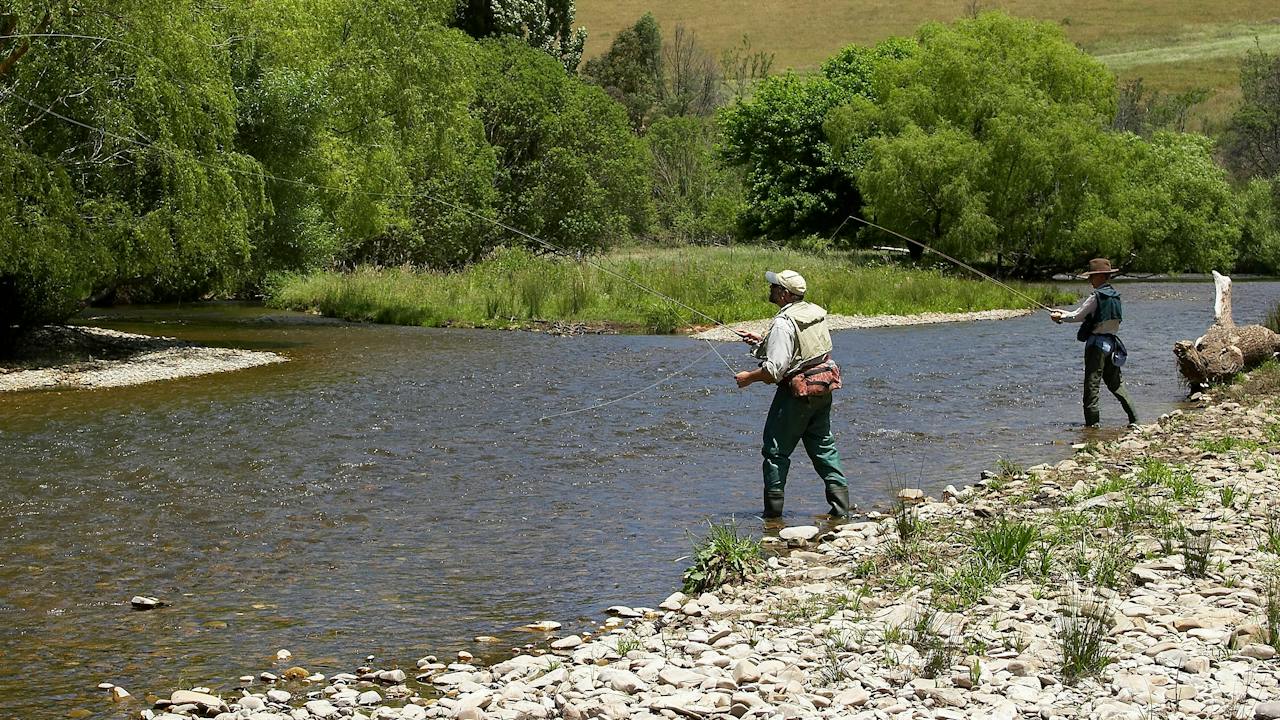
Cast your line in one of the many streams, creeks or river near the Burrowye Reserve for Brown and Rainbow Trouts, Redfin, and Murray Cod.
Suitable for caravans and camping - must be self-sufficient. Always check the water conditions and currents before swimming.
Flowering heaths, quiet beaches and abundant wildlife make this park a place to retreat, relax and appreciate the splendour and peace of the natural environment.
Explore the park on one of the several walking tracks and discover diverse coastal habitats. Burrum Coast National Park is spread over four sections, south of Bundaberg.
You will find mangrove-lined riverbanks, wallum heath with spectacular wildflowers and tea tree dominated wetlands where huge cabbage palms reach through the canopy. Areas of deeper soil support eucalypt forests, including the vulnerable Goodwood gum Eucalyptus hallii.
In the Kinkuna section, enjoy the narrow picturesque beach, low coastal dunes, tea-coloured waterways and flat sandy plains.
Explore the Woodgate section on a wheelchair-accessible boardwalk across a melaleuca swamp (look for the cabbage palms) or along walking tracks to viewing and fishing platforms, and a bird hide. Canoe across the river, go birdwatching your try your luck at fishing.
Enjoy camping at Burrum Point or behind the dunes at Kinkuna (both four wheel drive access only). In late winter and spring, delight in the wallum heath wildflower 'show'.
The magazines are significant for their association with the construction of the North Australian Railway which was an important factor in the opening up of the Top End of Australia.
The underground magazine, built in 1885, demonstrates a high degree of technical achievement. Designed in Glasgow by Nobel's Explosives Co Ltd it consists of an underground concrete chamber with a vaulted entrance stairway. It is one of two known to exist in the Northern Territory. The above ground magazine was built in 1896. It consists of a rectangular storage area with a vaulted ceiling. A system of air vents has prevented the ingress of water and has been very effective in stabilising air temperature and humidity. There is evidence that this magazine continued to be used for explosives until World War 2. The magazines are the only intact buildings in or around the Township of Burrundie.
The walls of the Burrungkuy (Nourlangie) rock art site, in World Heritage-listed Kakadu National Park, have served as a shelter and canvas for thousands of years. The paintings are a window to a rich spiritual tradition and can be reached by the circular 1.5 kilometre Burrungkuy (Nourlangie) rock art walk.
In the dry season, hear a park ranger speak this about ancient gallery and the relationship of the local people to their country and beliefs.
In the main (Anbangbang) gallery you’ll see the Creation Ancestor Namondjok, and the Creation Ancestor Namarrkon, the Lightning Man. Climb to the Kunwarddewardde Lookout, and be rewarded with sweeping views of both Kakadu’s escarpment and Burrungkuy (Nourlangie Rock).
An entry fee is required to enter Kakadu National Park. Save time on your holiday and purchase your Kakadu park pass online before you leave home.
Burrungule Park Paintball and Laser Tag offer fantastic outdoor entertainment, with an impeccable safety record. They have facilities for both paintball and laser tag. Perfect for birthday parties, buck shows, family groups, social clubs and sports teams.
Laser tag is suitable for players from six years of age, and paintball from ten years of age and is great for team bonding and corporate team building. They supply players with overalls and protective head gear, with ladies also receiving gloves and chest protectors. The field is located just 2km from Mount Gambier.
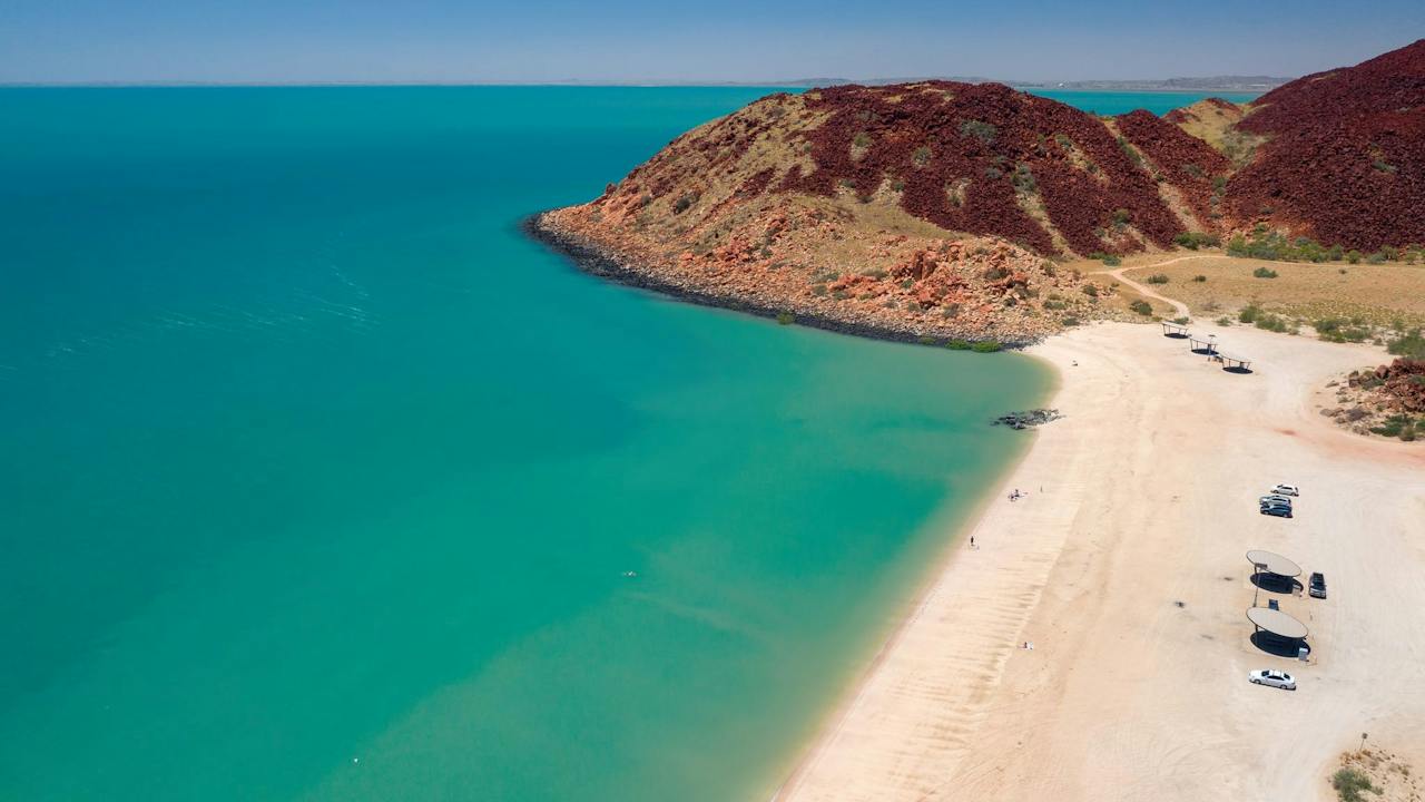
The Burrup Peninsula is a rugged coastal headland near the town of Dampier on Western Australia's Pilbara coast, characterised by rocky landscapes, sheltered bays and sweeping ocean views. Located adjacent to the Dampier Archipelago, the peninsula forms an important part of the wider coastal environment that shapes this distinctive region.
The peninsula includes a mix of protected areas, coastal recreation sites and working industrial zones, with Murujuga National Park occupying a significant portion of the landscape. Coastal locations such as Hearson Cove offer opportunities to enjoy beaches, tidal flats and seasonal natural phenomena, while elevated areas provide outlooks across the archipelago and surrounding waters.
Easily accessed from Dampier and nearby Karratha, the Burrup Peninsula serves as a gateway to a range of land and sea-based experiences in the Pilbara.
It also forms part of the broader Murujuga Cultural Landscape, recognised internationally for its outstanding cultural value.
Exploring the Burrup Peninsula allows visitors to orient themselves within this unique coastal setting and connect with the landscapes that define one of Western Australia's most complex and compelling regions.
Burswood Park is a 56-hectare sprawling parkland located on the banks of the Swan River on the popular Burswood Peninsula.
Situated in the inner south-eastern suburb of Burswood within the Town of Victoria Park, the park boasts city views and is within walking distance to some of Perth’s premier destinations – including the Matagarup Bridge, Optus Stadium and Crown Perth.
Less than five kilometres from the city and 15 minutes from the airport, Burswood Park is a popular venue for locals and tourists alike, with its sweeping landscaped parklands, local fauna, manicured gardens and pathways.
The park is fully accessible, with ample parking and public transport options and an array of attractions for people of all ages and abilities to enjoy.
Burswood Park is a part of the lively Burswood Peninsula, just minutes from the city and home to some of Perth’s most significant entertainment, sporting, hospitality and tourism icons.
Refer to the Burswood Park website for more information on what’s near Burswood Park.
Discover a vital piece of Western Australia's civic history at the Burt Memorial Hall, a beautiful community building standing proudly in the centre of Perth's Cathedral Square precinct. Positioned adjacent to St George's Cathedral, this historic landmark was constructed in the elegant Gothic Revival style. It serves as a lasting symbol of Perth's prominent Burt family, who played a deeply significant role in the government of the Swan River Colony during its foundational years.
Following decades of wear, the building underwent a meticulous, sympathetic restoration as part of the broader Cathedral Restoration Project, officially reopening its doors to the public in 2014. Today, the revitalised space functions as a versatile and vibrant hub for the local community, regularly hosting a diverse variety of Cathedral and diocesan functions, public receptions, educational workshops, school group visits, and rotating cultural exhibitions.
Located at 38a St Georges Terrace, this heritage-listed gem is an essential stop for architectural enthusiasts, historians, and tourists exploring the city's foundational colonial roots. While the hall's interior access is primarily subject to scheduled events, functions, and exhibitions, its striking exterior can be admired free of charge 24/7. The fully accessible venue is perfectly situated steps away from premium precinct dining, central CBD public transit hubs, and the historic Perth Town Hall.
Burwood Chinatown is a vibrant destination in the heart of Sydney, renowned for its authentic and diverse Asian street food.
Home to over 50 hawker-style eateries, it offers a mouth-watering mix of nostalgic home-style dishes and the latest food trends from across Asia. From charcoal-grilled skewers and hand-pulled noodles with slow-cooked beef to hotpot trains and fluffy artisan soufflés, there is something to satisfy every craving.
While Chinese cuisine is a highlight, the experience doesn't stop there. Visitors can also discover bold and flavourful dishes from Thailand, Malaysia, Korea, Japan, and beyond—making it a truly Asian culinary adventure.
As the sun sets, the excitement continues. The night market transforms the precinct into a buzzing, neon-lit destination, serving creative global flavours in a festive street atmosphere.
But Burwood Chinatown is more than just a place to eat. It's a cultural hub where people come together to celebrate food, heritage, and community. With its distinctive local charm and strong identity, it captures the essence of Sydney's multicultural spirit.
Whether you are here to explore, savour the food or simply enjoy the lively surroundings, Burwood Chinatown offers something for everyone. Come and discover it for yourself.
From high on the escarpment, you can look down at historic Burwood Colliery. It was first excavated in the 19th century, around 1861. It’s now well-preserved and part of the State Heritage register. Listen for the call of bellbirds. Look for the male regent bowerbird, with its glossy black and bright yellow plumage. Echidnas can also been seen out foraging at dawn or dusk.
The trail begins on Scout Camp Road above the scout camp. You'll see the track entry opposite the water tank. Walkers can join Yuelarbah walking track at the western end of the track or the Leggy Point loop walking track at the eastern end, which also links to Glenrock Beach. Horse riders can also use this trail, which joins into a network of others in the park.
The Bush Beautique is a wonderland of unique designs, colourful prints, and cozy, relaxed-style clothing, located in the rural town of young NSW.
Designed and made in-store by award winning designer Samantha Stolhand, the Bush Beautique offers a wide range of women's apparel and accessories, and bespoke creations!
Support a bush-based business and enjoy a personalised shopping experience, with all the quirky trimmings.
Nestled on the banks of Lake Fred Tritton, the Bush Tucker Garden in Richmond is a serene spot perfect for nature lovers and those interested in the region’s heritage. Wander through the garden and learn about native plants and their traditional uses, providing a unique educational experience.
The garden’s waterfall symbolises the origin of Richmond's water, flowing through the basalt country and surrounded by white gravel, gidgee stones, and moonrocks that enhance its natural beauty. It’s also an excellent location for bird watching, offering a peaceful retreat for enthusiasts. Visitors can access Bush Tucker Garden Plant Lists and Richmond’s Bird Lists at Kronosaurus Korner to further explore the local flora and fauna.
Enjoy a leisurely stroll through the St George Bush Tucker Garden to discover the local heritage, educate yourself about native edible plants like quandong trees and supplejack vines and while you're there check out the scar trees, all the while enjoying the diverse species that inhabit the garden.
Consider bringing a picnic to prolong your visit and immerse yourself in the natural surroundings.
Walk along the banks of Billabong Creek, beginning at the Steel Wings in Luke Park, and be tempted by the bush tucker plants along the track. Explore the humpy on the east side of the creek.
The bush tucker trail is incorporated into the Horgan Walk that follows along the Billabong Creek, where you walk over little footbridges, sit among the gum trees and enjoy the flora and fauna within the Jerilderie oasis.
At Bushfield Farm Camels, you can experience the magic of the outback while still being close to the city. Their gentle camels are ready to take you on a unique, slow-paced adventure, offering a peaceful escape from everyday life.
Perfect for families, the farm offers more than just a camel ride - it's an amazing escape from devices and city sounds, a chance to connect with nature, cuddle a camel experience the peace and beauty of Australia's iconic landscapes without the long journey. Come spend some time surrounded by the laughter of kids and the company of all the farm animals.
Happiness has a new name, and it's spelled C-A-M-E-L!
Open seven days. Bookings Essential.
Bushland Beach is a beautiful stretch of beach in a suburban area, with visitor accommodation and facilities available. Ideal for fishing, swimming, walking and water activities. Low tide uncovers an old wooden shipwreck. The beach is well serviced with a resort, barbecue facilities, playgrounds and a boat ramp.
Bushland Beach is part of the Northern Beaches area of Townsville, located 25 minutes drive from Townsville's central business district. Access to Bushland Beach is via a turnoff along the Bruce Highway.
Book your daypass now!
Step into a living story at the Bushland Boardwalk in Agnes Water / 1770, Queensland where every footstep brings you closer to the heartbeat of the bush. This 386-metre, all-access boardwalk winds through a stunning pocket of native forest alive with colour, sound, and movement. But listen closely—it's not just birds singing here.
Native bees hum with purpose through the wildflowers, pollinating bush blossoms with quiet determination. From the tiniest blue-banded bee to the gentle stingless varieties, these local legends are the unsung heroes of the forest. Watch them flit between grevilleas, hover near honey-myrtles, and dance in sunbeams as if to welcome you to their world.
Birdlife is also abundant—rainbow bee-eaters, fairy-wrens, and honeyeaters are just a few of the characters in this natural play. Join a BushTracks Eco Tour and experience forest bathing like never before. Feel the bark, smell the earth, and lose yourself in the stories told by trees, insects, and the breeze.
Accessible, immersive, and unforgettable—this is not just a walk, it's a wild encounter.
Explore the cultural and historical heart of Parkes at Bushman's Hill, a scenic site combining natural beauty, Wiradjuri heritage, and gold rush history. Located just off the Newell Highway opposite Kelly Reserve, or accessible via Wentworth Street, the hill features walking tracks that lead to the summit with panoramic views and historic mining relics.
Over 100 years ago, Bushman's Hill was the site of one of Parkes' first gold mines. Today, it offers a peaceful space for walking, learning, and reflection.
The precinct is also home to the Wiradjuri Amphitheatre and Garradyang Cultural Garden, which honour the Wiradjuri people, the traditional custodians of the Parkes region. These culturally significant areas are used for community events such as NAIDOC Week and feature Indigenous artworks by local Wiradjuri artists, scar trees, showing traditional bark harvesting and a bush tucker garden highlighting native edible plants
The Wiradjuri Nation is the largest in New South Wales, extending from Albury in the south to Coonabarabran in the north, covering nearly one-fifth of the state. The Wiradjuri people have lived on and cared for this land for over 40,000 years, with a deep spiritual and cultural connection to Country.
Whether you're interested in local history, Aboriginal culture, or a scenic walk, Bushman's Hill and the Wiradjuri Amphitheatre offer a rich and meaningful cultural experience.
In the history of South Australia it is thought that there was only ever one genuine bushranger. John Francis Peggotty, known as the "Birdman of the Coorong" was one like no other, pursuing his profession on the back of an ostrich!
Before the end of his career in 1899 Peggotty was credited with more than a dozen hold-ups and murder of several travelers in the area. On one such occasion a local fisherman was less than impressed being held-up by the ostrich and its rider and being a great shot with a long rifle, wounded the rider and killed the ostrich.
When inspecting his work the fisherman found only the corpse of the ostrich as the wounded Peggotty had scampered off leaving a trail of blood in the sand - to this day his remains have not been found in the dunes of the Coorong.
On the shore of Lake Albert at Meningie you will find a statue of an ostrich in memory of this adventurous man.
Enngonia is associated with two bushrangers stories. In 1868 Captain Starlight mortally wounded Constable McCabe of the Bourke Police at the local inn. He was pursued west and captured some months later on Mt Gundabooka.
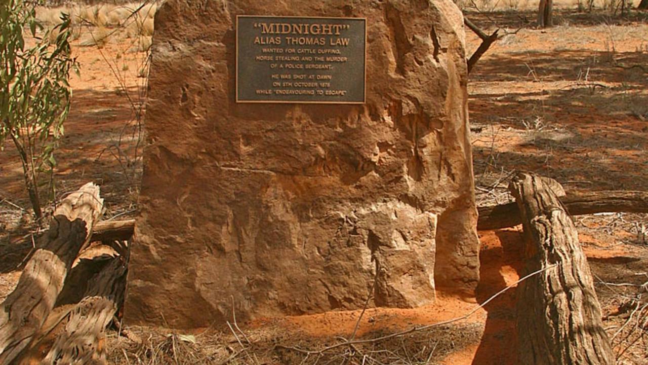
Bushranger Midnight was also pursued from Enngonia in 1878 and shot near Wapweelah. His grave can be found 39 kilometres west of Enngonia.
Trek over Irrara Creek about 700 metres where you will see a hut on your left, just past there is a gate and 150 metres from the gate is a stone monument.
Although Midnight was wounded near Wapweelah, he died in a hut not far from his grave.
For more information on the history of Enngonia, please visit the VisitBourke website and visit the Enngonia listing.
The beautiful Bushrangers Bay comprises a sandy beach surrounded by basalt cliffs on the ocean side of the Mornington Peninsula. Swimming is not recommended at this site as the beach is unpatrolled and often hazardous due to strong rips and large waves.
This serene location is contrasted by dark and brooding headlands and wild waves that often crash onto jagged rocks guarding the entrance to the bay.
Bushrangers Bay can be accessed via a walk along Main Creek from the Boneo Road car park and picnic area (2.5 kilometres). This section of the Two Bays Walking Track provides fine views and passes through shady Banksia groves.
Alternatively, follow the 2.6 kilometres Bushrangers Bay Track from the Cape Schanck car park to see some of the best coastal scenery near Melbourne.
There is limited or no mobile phone reception.
Bushrangers Bay is a high risk area with many unpredictable dangers not visible to the eye. Swimming is not recommended, however if you choose to please take extreme care, know the conditions and your limits, this beach is unpatrolled and it is recommended to only swim between the red and yellow flags, never swim alone and do not let children out of site or reach.
Bushrangers Bay Aquatic Reserve is located within Bass Point Reserve, just south of Shellharbour Village.
Known as an excellent sheltered site for snorkelling and scuba diving, with an inner and outer bay. The four-hectare aquatic reserve protects abundant plant and sea life.
The intertidal rock pools are home for many invertebrates. One of the most striking features within the reserve is a cliff shaped like an amphitheatre. In 10 metres of water, the cliffs are six metres high and contain hundreds of small cavities, which are home to sea urchins and tropical fish.
This is a protected area which means your are not permitted to fish by any method. Within the reserve, divers and snorkellers are requested not to touch the soft corals as they break off easily. Fishing or destroying marine life, including removing empty shells, is not permitted within the reserve.
Find out more about the history of Shellharbour by downloading "Tread Shellharbour" App and taking a virtual tour.