Places worth discovering

Things to Do

Find attractions, experiences and places to visit. Events remain the best way to see what is happening on a particular date.

Looking for a dated event? Explore Events

21 places

Explore local places

Bluff Track Fitness Trail
Image credit: Rowena Nicholls

Natural Attractions

Bluff Track Fitness Trail

Keep fit walking, jogging or cycling the Bluff Track Fitness Trail - previously known as The Whitemark to Pats River Walk. The one-hour (5 km return) coastal walk to the tidal salt marsh begins at the northern end of the esplanade in Whitemark, start out on the beach at low tide or follow the gravel road, watch out for the blue 'Bluff Track' sign on your left approximately half a kilometre from the sealed road. Extend the walk at low tide and continue on around the point towards the Airport, returning along Boyes Road to the Bluff Road and the Track. Walkers can also begin at the Bluff Road end via driving to Bluff Road, left off Palana Road just before the turnoff to the airport if you're coming from Whitemark. Toilets, picnic tables, free gas barbecues and tank water are available at nearby Whitemark Foreshore. Classified as a Level 1 walk with general slopes and solid gravel surfaces, best at low tide if you are planning to walk on the beach. Check the local weather for tide times. Extra energy to burn try out the exercise equipment on the Whitemark Foreshore just past the free gas barbecue and toilets. This track is also used on Saturday morning's 9 am Parkrun.

Whitemark TAS

2.5 km away

View place
step back in time
Image credit: Bowman History Room

Historical Sites and Heritage Locations

Bowman History Room

The Bowman History Room offers a unique historical collection, located in Whitemark, Flinders Island. The room was created in 1996 to celebrate the 75th anniversary of the Bowman Family business, E M Bowman & Co Pty Ltd, established in 1921. So they are now beginning their 105th year! This amazing collection of shop items, photographs and account books from 1921 onwards traces both the growth of one family and their business and also the development of the town of Whitemark and Flinders Island as a whole. The most perused item is the huge scrapbook of newspaper and magazine articles collected over many years by Elvie Bowman. You will find catalogues and account ledgers that depict a vastly different world to today's world. Memories will flood back for older generations, while younger generations will wonder how people survived without modern conveniences. Entry fee of a gold coin donation goes to the Furneaux Historical Research Association. While you are visiting Flinders Island you can also experience the Patriarchs Wildlife Sanctuary, Wybalenna Historic Site and the Furneaux Museum. The jagged peaks of Strzelecki National Park can also be explored along with amazing beaches. Flinders Island is a 30-minute flight away from Launceston or just under a one-hour flight from Melbourne.

Whitemark TAS

2.9 km away

View place
Whitemark Foreshore Picnic BBQ Area
Image credit: Flinders Council

Natural Attractions

Whitemark Foreshore Picnic BBQ Area

On the Whitemark Esplanade, just before the exercise equipment, you'll find an area with a shaded gas BBQ and picnic tables. Available for day use, the gas for the BBQ is generously provided by Flinders Council. While a rainwater tank supplies freshwater for handwashing, bringing your own drinking water is recommended. The beach offers shallow, safe waters, making it an ideal spot for children, especially during mid to high tide when the water warms over the sand. Dogs are welcome, and there's plenty of beach to explore. For those interested in a longer walk, the Bluff Track offers a 5 km return journey along the foreshore, leading to Bluff Road. Spend the evening taking a sunset walk on the beach, building sandcastles, or collecting shells. Keep an eye out for Paper Nautilus Shells, or Argonauta nodosa, which wash ashore between March and June. Fishing enthusiasts can purchase bait at the local pub and try their luck catching squid or trevally off the jetty.

Whitemark TAS

3.2 km away

View place
Lichen on granite rocks Flinders Island
Image credit: Flinders Island Tourism and Business Inc

Natural Attractions

Drive Discovery North Flinders Island

From Whitemark, drive north to Killiecrankie Bay. Take a stroll along this beautiful beach overlooked by the impressive Mt Killiecrankie. If you have some time, get local advice about the best places to fossick for Killiecrankie diamonds or try Diamond Creek, about 2 km along the beach. Climb Mt Killiecrankie. Picnic at the free gas barbecue picnic area at Killiecrankie Beach or further north at Palana Beach. At Palana, take the signed track to the wide sandy beach that is ideal for a long beach walk or often has enough swell for safe body surfing. The tiny group of shacks at Palana was set up as a Radar Station during WW2 when the fear of a Japanese invasion was at its peak. Observe the lichen-covered rocks and enjoy the white sandy beach with sweeping views to Inner Sister Island. Turn off to North East River to see Flinders Island's most northern tip experience wildlife, fishing, great beaches with coastal vegetation. Explore the wild ocean beach pounded by surf and follow the estuary to see the variety of seabirds living here. Don't forget to wave at every passing motorist.

Whitemark TAS

3.2 km away

View place
Begin your drive in Whitemark
Image credit: Flinders Island Tourism and Business Inc

Landmarks and Buildings

Drive Discovery Central Flinders Island

Drive to Walkers Lookout for sunrise over the Darling Range or take an early morning beach walk near Whitemark. In Whitemark take a stroll along the Bluff Fitness Track to allow an hour for the easy coastal walk. Or drive just north of the town and take Bluff Road to view the birdlife in this tidal salt marsh. Continuing north, stop in at Long Point or Sawyers Bay beaches before making your way to the coastal townships of Emita and Settlement Point. Spend time at the historic site of Wybalenna. Picnic and discover the secluded coves and sandy beaches at Allports, Emita and Lillies. With safe swimming and crystal clear waters, they are all ideal for snorkelling. Call into the Furneaux Museum in the afternoon (check opening days). Do the coastal walk to Castle Rock from Allports Beach to Marshall Bay. At dusk, head to the Shearwater viewing Platform near Port Davies and watch mutton birds return to their burrows to feed their young chicks. Return to Whitemark via Walkers Lookout – magnificent sunset colours along the face of the Darling Range and looking back towards Mt Strzelecki. Remember to wave at passing motorists.

Whitemark TAS

3.5 km away

View place
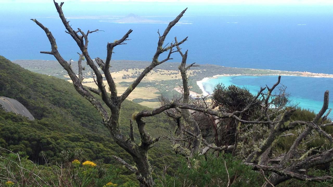
Forthingate Bay from Strzelecki Peak Walk
Image credit: Rowena Nicholls

Natural Attractions

Strzelecki Peaks Great Short Walk

The large granite massifs of Strzelecki National Park were formed during a major continental collision in eastern Australia, approximately 370 million years ago and dominate the southern part of Flinders Island. The Strzelecki Peaks 4-5 hour return walk climbs to the top of the 756m granite mountain, with breathtaking views from the summit on a clear day you can see mainland Tasmania. This is one of Tasmania's Great Short Walks. Park entry fees of (https://parks.tas.gov.au/explore-our-parks/know-before-you-go/park-passes-and-entry-fees) per vehicle apply and can be paid at Service Tasmania in Whitemark. Annual pass holders, please bring your 'Annual all parks card' to Flinders Island. The nearest facilities are located 3.5km away at Trousers Point including toilets, drinking water (tank), free gas barbecues, picnic tables and campsites. Classified as a Level 4 walk. Steep uphill walk requiring physical exertion. However, there is nothing technically difficult about the walk. The walk starts at an elevation of 20m and finishes at 756m. The summit can be cold and windy. For personal safety, please sign the register at the base of the summit and do not attempt the walk on Total Fire Ban days. The 60 Great Short Walks app is available now free from iTunes.

Flinders Island TAS

13 km away

View place
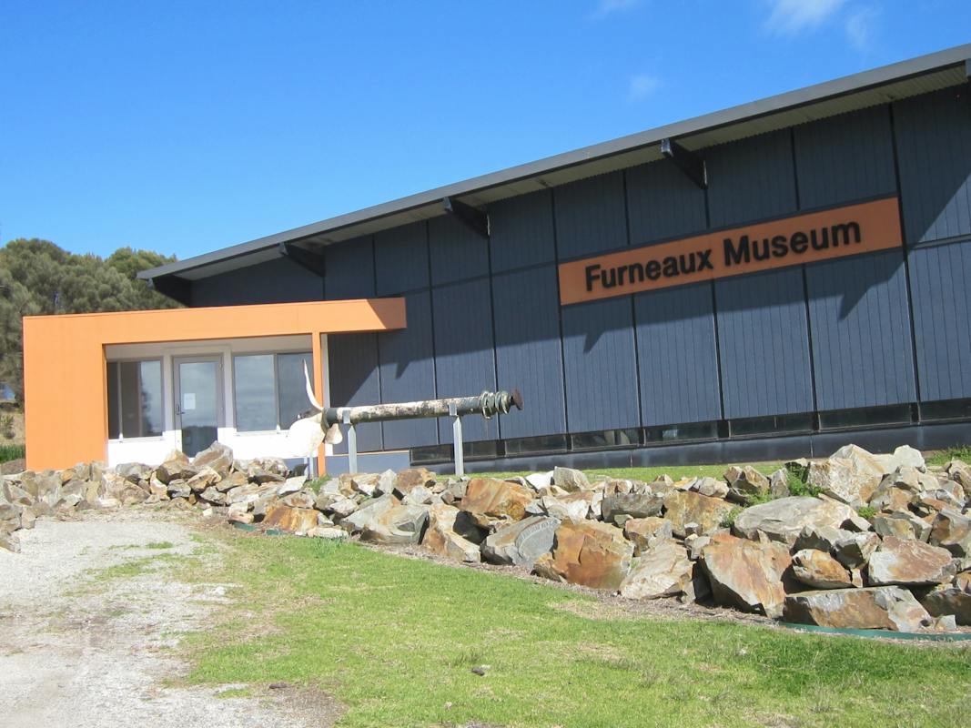
Museum ntrance
Image credit: Futneaux Museum

Galleries, Museums and Collections

Furneaux Museum

The Furneaux Museum is located at Emita on Tasmania's Flinders Island and is devoted exclusively to the cultural and natural history of the Furneaux Islands in eastern Bass Strait, where some of Australia's earliest European history took place. Shipwreck artefacts are a highlight, including an anchor from the 1797 wreck of the vessel 'Sydney Cove' - an event that led to the arrival of sealers and, through them, the survival of Tasmania's indigenous population. There are many relics from other shipwrecks that occurred around the islands. The history of the fateful 1840s Wybalenna settlement is recorded in the Aboriginal Room, which also displays a rare collection of 100-year-old traditional Aboriginal shell necklaces. The Mutton Bird Processing Hut gives an authentic glimpse into the island tradition of 'birding'. Other exhibits demonstrate the geology, fauna, shells, and early pioneering life of the islands. Over 160 albums of photographs and documents cover almost all aspects of life in the Furneaux Islands from the past up to the present day. The museum is operated entirely by volunteers. Opening and closing times can be found on the website or by phoning the museum at any time.

Flinders Island TAS

13 km away

View place
Furneaux Geotrail

Natural Attractions

Furneaux Geotrail

Discover the stories written in the landscape across Flinders Island, and its surrounding Bass Strait archipelago along the Furneaux Geotrail. Use the Geotrail as a companion guide to learn more about the places around you as you visit the island's most popular visitor attractions. Please be on the lookout for the Geotrail signage on your travels to help you explore the local geological heritage of Flinders Island. As a web app, it is easy to save to the home screen of your mobile device to provide easy one click access to a variety of further landscape information about the island's heritage hotspots. There are 26 geosites located across Flinders Island where you can explore and learn about the stories that define the landscape.

Emita TAS

14 km away

View place
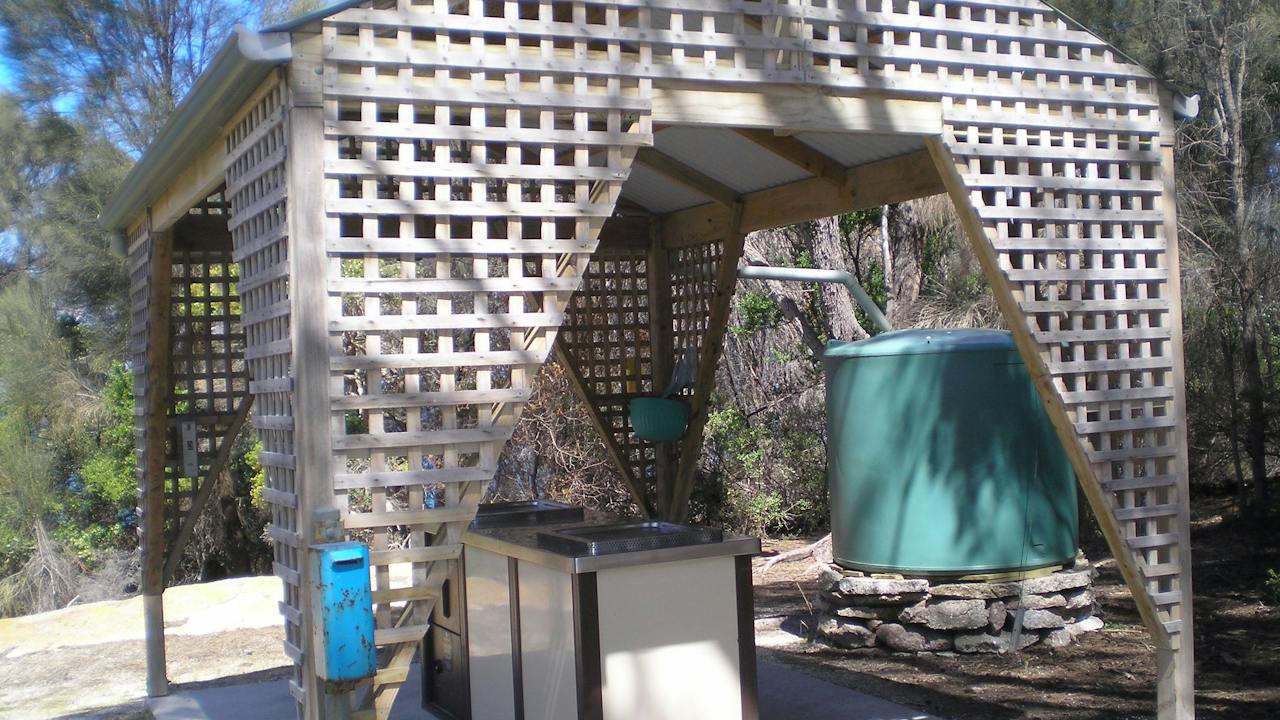
free gas barbecue at Allport Beach
Image credit: Rowena Nicholls

Natural Attractions

Allports Beach Picnic Area

Just before you hit Allports Beach, you'll find a day-use area complete with a gas BBQ, shaded picnic tables, and restroom facilities. The barbecue gas is generously provided by Parks and Wildlife, and although the BBQ is free to use, donations are welcomed. Handwashing is possible thanks to dual rainwater tanks; however, it's recommended that you bring your own potable water. The beach itself stretches 150 metres, curving gently to the north and featuring a relatively steep reflective shoreline. It's framed by granite points adorned with dunes, while the eastern edge boasts boulder outcroppings. Seagrass meadows flourish about 100 meters from the shore. A convenient road leads down to the amenities at the beach's eastern tip, where you'll find a parking lot and picnic space. As Emita's primary swimming spot, the beach is child-friendly and offers excellent snorkelling opportunities near the rocky areas. Situated approximately 100 metres from Allports Beach is a campsite with a few picnic tables and ample room for several campers. Short-term camping is permitted and there's no need for reservations -spaces are allocated on a first-come, first-served basis.

Emita TAS

14 km away

View place
view from the picnic area Lillies Bay

Natural Attractions

Lillies Bay Picnic area

The area is equipped with picnic tables and a long drop toilet, but drinking water is not available. Pets are welcome, and groups will enjoy the spacious beach and many activities the area lends itself too. The beach is ideal for snorkelling and swimming with shallow, crystal clear waters, rocks and an old jetty to explore. With a view back towards Mt Strzelecki and a prime location for sunsets, photographers will delight in the changing light and photo opportunities the beach offers. To get there, head along Port Davies Rd from Palana Rd, passing Wybalenna historic site, until you reach the rough track to Lillies Bay. Continue on Port Davies road to the mutton-birding viewing platform or boat-launching facilities at nearby Port Davies.

Emita TAS

14 km away

View place
Trousers Point free gas barbecue
Image credit: Flinders Island Tourism and Business Inc

Natural Attractions

Trousers Point Picnic Area

Trousers Point is one of those beaches that stops you in your tracks. Known as one of the most picturesque spots on Flinders Island, it has a way of leaving visitors a little bit awestruck. With shallow, crystal clear waters and a gentle sandy entry, it's safe for kids and perfect for a swim, while photographers will love capturing the sweeping views and dramatic headlands. As part of Strzelecki National Park, Trousers Point is cared for by Parks and Wildlife. You'll need a Parks Pass before visiting, which you can pick up from Service Tasmania or through local car hire outlets. The reserve is well set up for a full day out, with picnic tables, BBQs, toilets, changing sheds, and tank water. There's also a sheltered camping area if you'd like to stay a little longer under the stars. And the name? That's a story in itself. Some say it comes from Richard Burgess, who escaped a nearby shipwreck trouser-less, while others reckon it was a box of trousers washed ashore from the Cambridgeshire in 1875. Either way, it's a name you won't forget for a beach you'll always remember.

Flinders Island TAS

15 km away

View place
Trousers Point free gas barbecue area
Image credit: Flinders Island Tourism ad Business Inc

National Parks and Reserves

Trousers Point Great Short Walk

Trousers Point sits under the gaze of Mt Strzelecki and is known not only for its unusual rock features and two beautiful beaches, but also for its stunning ocean views taking in several off-shore islands. Trousers Point Beach is the most photographed and celebrated beach on the Island with crystal clear waters, wide expanses of white sand, and a mountain rising from the ocean. On the other side of Trousers Point is Fotheringate Bay with granite caves formed by emerging groundwater, marine erosion and alveolar weathering of cliffs. Trousers Point Walk, which circumnavigates the point from Trousers to Fotheringate in a 1.5-hour circuit is one of Tasmania's Great Short Walks. Park entry fees apply and can be paid at Service Tasmania in Whitemark. Annual pass holders please bring your 'Annual all parks card' to Flinders Island and display it on your vehicle. Toilets, drinking water (tank), gas barbecues, campsites (un-powered) at Trousers Point. Picnic tables at Fotheringate Beach. Classified as a Level 2 walk with short rocky sections that can become slippery when wet. Steep cliffs adjacent to the track in some sections. Walkers are advised to stay on the track and supervise children. Download the 60 Great Short Walks app free, from the iTunes Store.

Flinders Island TAS

15 km away

View place
View Mutton birds on dusk from the viewing platform
Image credit: Rowena Nicholls

Natural Attractions

Settlement Point Viewing Platform

The Settlement Point viewing platform at Emita is the ideal location to watch the Shearwaters (Mutton birds) return to their burrows at dusk, after a day of feeding far out at sea (November to April). The Short Tailed Shearwater, more commonly known as the Mutton-Bird is a member of a group of 100 medium to large seabirds in the family Procellariae. The breeding period for these birds is September through to April; they breed in burrows about 1 metre long. In November, after spending the last couple of months meeting up with their mate and tidying up their burrow, the mutton birds leave the colony for a short time to feed before returning to lay a single egg. The chicks hatch in late January with both parents participating in its feeding and care. The parents leave the down-covered chicks in early April and the chicks do not eat again until early May, so they rapidly lose weight as they acquire their flight feathers. 2-3 weeks after the parents have left the fledglings will begin their first migratory flight unassisted by experienced birds. The average life span of these birds is 15-19 years with some living to 38.

Flinders Island TAS

15 km away

View place
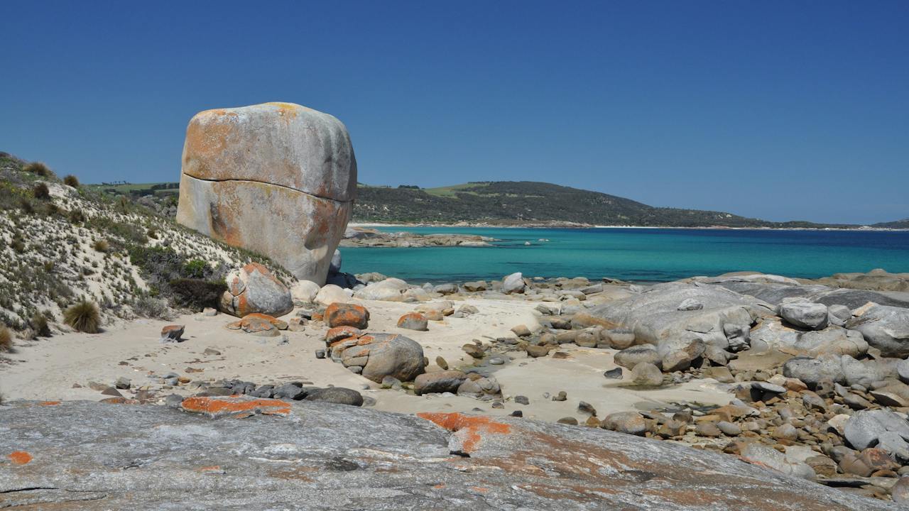
Castle Rock looking towards Settlement Point
Image credit: Flinders Island Tourism and Business Inc

Natural Attractions

Castle Rock Great Short Walk

The Castle Rock Walk is one of Tasmania's Great Short Walks, it meanders along the shoreline of Marshall Bay, crossing stunning beaches and coastal hinterlands on its way to Castle Rock, a massive granite boulder. The 3 hour return beach walk begins at 'Castle Rock track and car park' just before Allports Beach. Walkers can also begin at the Marshall Bay end via the Marshall Bay Access Track on the left off Palana Road just after the sealed road becomes gravel if you're coming from Whitemark. Park on the hill overlooking the Bay a five minute walk along the dirt 4WD track on your left will bring you to Castle Rock. Toilets, picnic tables, free gas barbecues and tank water are available at nearby Allports Beach, including a designated camping area. Classified as a Level 2 walk moderate grade with no steep sections. Generally, a very safe walk, best at low tide, check the local weather for times, however, walkers should watch out for large waves during big seas if attempting the walk at high tide. Download the 60 Great Short Walks app free from the iTunes Store.

Flinders Island TAS

16 km away

View place
Strzelecki National Park
Image credit: Photographer copyright (Jordan Davis)

Natural Attractions

Strzelecki National Park

Mount Strzelecki is the highest point on Flinders Island and the namesake of this national park. The mountain’s distinctive peaks are even visible from mainland Tasmania. Visitors to Strzelecki National Park can take their pick of stunning beaches, turquoise waters and crisp white sand. Without the press of busier locations, you can take your time to explore the lichen-covered granite rock formations the encircle these quiet beaches. Swimming, snorkelling, fishing and kayaking are great ways to experience the coastal highlights of this striking national park on Flinders Island. There are also several walks that take you across the landscape, including an ascent across the majestic granite rocks to the summit of Mount Strzelecki. This climb will reward you with 360 degree views of this remote archipelago in Bass Strait. Please visit the Parks and Wildlife Service Tasmania website (parks.tas.gov.au) for further information about this national park including how to get there and things to do. Refer to the ‘know before you go’ webpage for more important information about alerts, safety in parks and entry fees.

Flinders Island TAS

16 km away

View place
Patriarch Inlet east coast Flinders Island
Image credit: Flinders Island Tourism and Business Inc

Landmarks and Buildings

Drive Discovery South East Coast Flinders Island

Beginning in Lady Barron, visit the port area or walk along the foreshore to Yellow Beach. Drive north to Cameron Inlet via Lady Barron Road turning off on Lackrana Road – for wetlands, waterbirds and remote beaches. Walk three kilometres south from Cameron Inlet along Planter Beach to the Planter Wreck, timber remains of a wreck believed to be the Brigantine shipwrecked in 1877. Continuing north, turning off at Memana Rd and driving on to Patriarch Inlet – migratory wading birds, picnic or beachcombing. Take the two-hour return beach walk, Patriarch Inlet to Red Bluff, easy 7 km (2-3 hours return) beginning from the southern end of Patriarch Inlet, look out for seashells and other washed-up treasures. Take Lackrana Road north to Memana, visit Tobias Furneaux Lookout (off Memana Road) and Walkers Lookout. Return to Lady Barron via the coast road and Badger Corner (turn right at Ranga). Call in at the Adelaide Bay bird hide to view the waters of the Franklin Sound and the abundant bird life. Remember to wave at passing motorists!

Lady Barron TAS

24 km away

View place
Coastal walk to Yellow Beach from Lady Barron
Image credit: Rowena Nicholls

Natural Attractions

The Lady Barron Foreshore Walk

The Lady Barron Foreshore Track (from the slipway to Yellow Beach) enjoys coastal bush, rocky outcrops, and spectacular views. Yellow Beach boasts an ideal swimming spot as well as a free gas BBQ, especially convenient for those arriving at an evening ferry. This walk features coastal vegetation, lichen covered granite and takes in the golden sands of Yellow Beach at low tide, use Pot Boil Road at high tide. The track is 1.75 km long and takes about 25 minutes to walk one way. It can be walked in either direction and takes around an hour return. There are steps in rocky outcrops and soft sand to negotiate, so a basic level of fitness is required. Please take care it can be slippery underfoot. As you wander through the Tea Tree, Kunzea and Paperbark lined track to look out for a variety of flowering plants especially in Spring, like greenhood and sun orchids. Many sea and shorebirds are often seen including Short-Tailed Shearwaters and sea eagles. Enjoy views of the many outer islands and glimpses of Franklin Sound towards Cape Barren Island as you wander along the track.

Lady Barron TAS

24 km away

View place
Yellow Beach BBQ Picnic Area
Image credit: Flinders Council

Natural Attractions

Yellow Beach Picnic BBQ Area

Head east along Franklin Parade until it turns to gravel and becomes Pot Boil Road, then keep an eye out for the Yellow Beach sign on your right. Yellow Beach is one of those easy, happy places – calm, shallow waters perfect for swimming, snorkelling, or paddling a kayak on a sunny day. There's a shaded gas BBQ, a shelter, picnic tables, tank water, and toilets, so you can settle in for a long, lazy afternoon. The area is for day use only, and with space for around 20 cars, it's a favourite for birthday parties, family picnics, and community get-togethers. Climb the viewing platform for a postcard-perfect outlook over Franklin Sound, with Big Green, Vansittart, Big Dog, Little Dog, and Cape Barren Islands laid out before you. If you're up for a wander, the Yellow Beach trail is a gentle 3.5 km return walk along the coast, winding back towards the boat slip and fuel depot in Lady Barron.

Lady Barron TAS

25 km away

View place
Killiecrankie BBQ Picnic Area
Image credit: Flinders Council

Natural Attractions

Killiecrankie Picnic Area

The Killiecrankie foreshore is a lovely spot to spend the day, with a complimentary gas BBQ, picnic tables, tank water, and a public restroom. There's also parking for up to 30 cars, making it perfect for group outings. At the southern end of the bay, you'll find Killiecrankie Beach at the end of Killiecrankie Road. Behind the western section of the beach sits a quaint little settlement on the lower slopes. The beach begins near low granite rocks and the sheltered waters around Nobby Rock, then stretches east for about 800 metres to the mouth of Killiecrankie Creek. With soft white sand and a gentle slope, it faces north across the bay. The western corner is usually calm, with clear water over a sandy terrace. Just offshore, about 100 metres out, you can spot rock reefs and seagrass beds. This end of the beach is also a popular launch point for small boats, and you might see a few fishing boats anchored nearby. If you're looking to stay overnight, there's a privately run campsite just a short walk from the beach. To book, give Jude a call on (03) 6359 8464.

Killiecrankie TAS

32 km away

View place
Tebrakunna Visitor Centre

Galleries, Museums and Collections

Tebrakunna Visitor Centre

With spectacular views of Bass Strait, the Musselroe Wind Farm is situated on land known as tebrakunna to the pairrebeener clanspeople, the traditional owners. The Tebrakunna Visitor Centre is named after the land and includes displays and information about the wind farm, the traditional landowners, the history of the Cape Portland property and the maritime and mining history of the greater North East region. For opening hours and directions visit the Woolnorth Wind Farms website.

Musselroe Bay TAS

74 km away

View place
Mount William National Park
Image credit: Joint copyright - PWS and photographer (Joe Shemesh)

Natural Attractions

Mount William National Park

Mount William National Park is a pristine paradise tucked away on the far North-East Coast of Tasmania, at the northern end of the Bay of Fires. This windswept coastline features rocky outcrops marked with bright orange lichen and seemingly endless stretches of powder-white sand that squeaks beneath your feet – all set against a backdrop of crystal-clear turquoise water. Mount William National Park is peaceful and relaxed, perfect for walking, fishing, swimming or kicking back at your beachside campsite doing nothing at all. The Park’s namesake, wukalina/Mount William, sits at 216m above sea level. From the summit, enjoy panoramic views of the coast and, on a clear day, all the way to the Furneaux Islands in Bass Strait. Mount William National Park is home to an abundance of Tasmania’s marsupials and, as you explore, you can spot kangaroos, wombats, wallabies and echidnas. The coastal birdlife is just as varied, with over 100 species. Please visit the Parks and Wildlife Service Tasmania website (parks.tas.gov.au) for further information about this national park including how to get there and things to do. Refer to the ‘know before you go’ webpage for more important information about alerts, safety in parks and entry fees.

Mount William TAS

88 km away

View place

What is happening now?

Search dated events, markets, live music, sport and community activities.

Explore Events

Planning by place?

Use Things to Do for attractions and experiences that are not tied to one event date.