Places worth discovering

Things to Do

Find attractions, experiences and places to visit. Events remain the best way to see what is happening on a particular date.

Looking for a dated event? Explore Events

127 places

Explore local places

Queen Street Playground

Sports and Recreation Facilities

Queen Street Playground

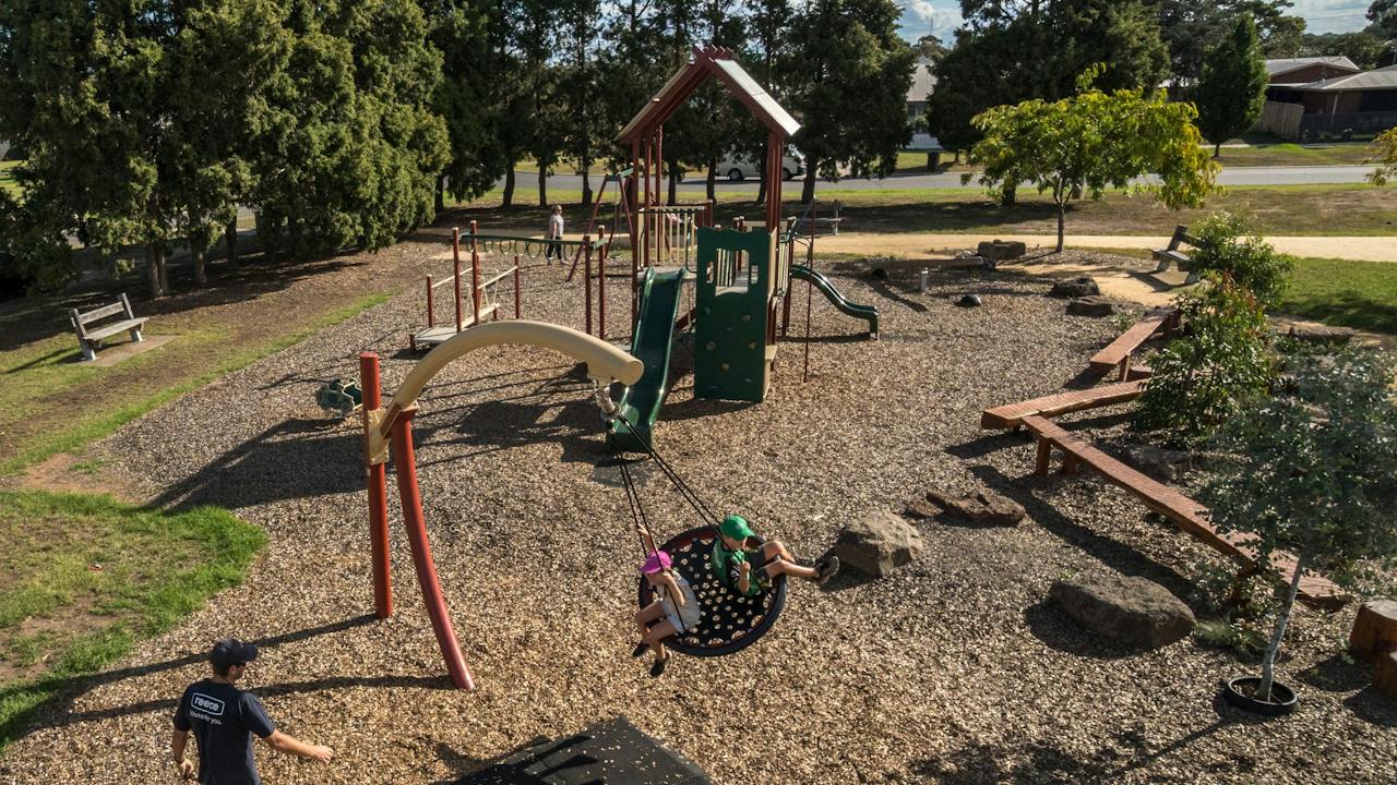
The Queen Street Playground has a small grassy area with wave slide, steps, hooped ladder, shop front, tic-tac-toe, little climbing wall, steering wheel, monkey bars and hanging disks. Springer and swings. Unshaded table and seat. The Queen Street Playground is a great space for the whole family to enjoy a great day out.

Rosedale VIC

0.2 km away

View place
Prince Street Reserve

Sports and Recreation Facilities

Prince Street Reserve

The Prince Street Reserve is a great place to stop with the family, with a life sized statue of the race horse, Patrobas to enjoy, along with a playground area for all ages. There are barbeque areas, seating and much more for the whole family to enjoy on a beautiful day.

Rosedale VIC

0.3 km away

View place
Rosedale Skate Park

Sports and Recreation Facilities

Rosedale Skate Park

Concrete park with an interesting hump in the middle which has a rail and ledge. At one end is a quarter combo with extension and there is a wall of banks at the other end. The quarters have a lot of vert. There are also two tables under a shelter, shaded and unshaded seats.

Rosedale VIC

0.4 km away

View place
Edward Crooke Park Playground

Sports and Recreation Facilities

Edward Crooke Park Playground

Well equipped playground with two wave slides, multi-level walkways, ladder with square rungs, climbing wall, half circle curved climber, tunnel, shop front, inclined balance beam, stepping stones, flying fox, balance beam with obstacles, chain traverse, monkey bars and disk steps. Springer, swings, huge stand-on carousel and log balance beam. Shelter with table and barbeque plus another shelter with a table. Big pleasant grassy areas dotted with trees, seats and unshaded tables.

Rosedale VIC

0.7 km away

View place
Holey Plains State Park
Image credit: Parks Victoria

National Parks and Reserves

Holey Plains State Park

Holey Plains State Park covers an area of 10,638 hectares of mostly Banksia and Eucalypt open-forest and woodlands growing in a series of low sandy ridges. Proclaimed in 1977, the park protects an extremely high diversity of native flora and abundant wildlife, while providing for bushwalking, picnicking, camping and other activities. Explore the park on foot on a number of different walks. Many of the tracks off Rosedale-Stradbroke Road provide easy walks and are particularly beautiful in spring when wildflowers are in bloom. Before you go Conditions can change in parks for many reasons. For the latest information on changes to local conditions, please visit the relevant park page on the Parks Victoria website. Be bushfire ready in the great outdoors. Refer to the Bushfire Safety section on the Parks Victoria website for tips on how to stay safe.

Rosedale VIC

6.9 km away

View place
Gippsland Armed Forces Museum
Image credit: Wellington Shire Council

Galleries, Museums and Collections

Gippsland Armed Forces Museum

The Gippsland Armed Forces Museum aims to preserve Gippsland's military heritage, and provide the means to display and highlight the role played by Gippslanders in the country's Defence Forces, both in peace and war. It is a regional military museum that researches, educates and displays the role that Gippsland men and women of have played in the defence of Australia in times of war and peace from 1885 to the present. The collection includes military service from 1885 to now, items vary from personnel items to weapons both longarm, smallarm and bayonets, as well as items from Gallipoli, France, and Belguim. Other displays depict photographs, maps and more. Incorporated into this collection is the Aucterlonie Collection.

Fulham VIC

17 km away

View place
Heyfield Wetlands

Natural Attractions

Heyfield Wetlands

The Heyfield Wetlands is a beautiful focal point for Heyfield and situated at the Wetlands overlooking a small lake is the Information Centre. For the public's enjoyment, four kilometres of walkways with eight exercise stations and boardwalks have been built on the twenty eight hectare reserve. The Wetlands offers a place for people to enjoy walking, exercising, bird watching, fishing, photography and outdoor events. Sitting beside the Information Centre is a barbeque, shelter and wheelchair-friendly picnic table for general use. The Information Centre is run by volunteers and can provide brochures, maps and booklets on what is available to see and do in the area. A lovely variety of local art and craft can also be purchased and at various times the centre is hired out for private functions with an electronic whiteboard available for use. Events hosted at the centre have included parties, weddings, funerals, conferences, meetings, craft groups, exhibitions and concerts. The Wetlands committee provides catering for functions on request. Please contact us for costing of hire and catering or pop in to say hello and have a look around.

Heyfield VIC

19 km away

View place
Apex Park Heyfield
Image credit: Wellington Shire Council

Natural Attractions

Apex Park Heyfield

Heyfield Apex Park is a beautiful park for both kids and adults situated right in the centre of Heyfield. Recently redeveloped the park has a magnifcent playground complete with wooden treehouse, giant swing, bouncy truck and australian animal wood sculptures. Many picnic tables are scattered amongst the trees and gardens, a dry creek bed meanders through the centre of the park and undercover free electric barbeques and toilet facilities are all available. For those wishing to take a stroll the Rail Trail passes right by and continues on past the Skate Park, the Migrant walk and on to the Lions Club Rotunda and Memorial Rose Garden. The perfect spot to take a break, let the kids release some energy, refresh and enjoy a relaxing lunch.

Heyfield VIC

19 km away

View place
Heyfield Skate Park and Pump Track

Sports and Recreation Facilities

Heyfield Skate Park and Pump Track

The Heyfield Pump Track can be found in Apex Park next to the Heyfield Skatepark. The pump track was opened in late 2020 and is still in premium condition, looking as good as new. Since opening, the pump track has been popular with bikes, scooters, and skaters alike. The tar pump track offers significant humps and bumps to gather heaps of speed and momentum. There are a number of different loops that you can choose, catering for overtaking lanes and a variety of alternative lines. A super fun, versatile skatepark that will get people rolling around with a smile on the dial.

Heyfield VIC

19 km away

View place
Cycling the Gippsland Plains Rail Trail, Gippsland, Victoria, Australia

Natural Attractions

Gippsland Plains Rail Trail

The Gippsland Plains Rail Trail is a 63 kilometre recreational trail following the former historic Gippsland Plains railway line route between Stratford and Traralgon. Location: Traralgon to Stratford Distance: 63 kilometres one way Track: Generally smooth dirt or gravel track Grade: Level One - No experience required Start: Intersection of Marshalls Rd and the Traralgon-Maffra Road (C105) Finish: Apex Park, Stratford, beside the Avon River Traralgon to Glengarry (10 kilometres) Pass through the scenic Latrobe River floodplain and over four spectacular restored bridges. Glengarry to Toongabbie (9 kilometres) This path leads to the peaceful Eaglehawk Creek, ideal for picnicking. Toongabbie to Cowwarr (9 kilometres) This section sets out across the plains with views towards the Great Dividing Range. Cowwarr to Heyfield via Dawson (11 kilometres) Head out of Cowarr past the scenic Rainbow Creek crossing and continue through the rich river flats. Heyfield to Tinamba (10 kilometres) The Tinamba Hotel makes for a great food stop. Tinamba to Maffra (8 kilometres) This section of the trail has an excellent surface and passes through wetlands, forest and a number of creek crossings. Maffra to Stratford via Powerscourt (10 kilometres) The trail follows the main railway line through quintessentially country landscape.

Traralgon VIC

20 km away

View place
Cowwarr Weir

Natural Attractions

Cowwarr Weir

Cowwarr Weir is a popular spot for recreation and non-powered water activities and is an ideal place for a day trip with the whole family. Cowwarr Weir is a spectacular spot that is well-patronised for swimming, kayaking, fishing and picnicking, with lots of shady spots by the water. There are pleasant walks around the reserve and it is popular with bird-watchers. There are picnic tables and toilets but please note there are no barbeque facilities. No powered boats are allowed on the weir.

Cowwarr VIC

20 km away

View place
Gippsland Performing Arts Centre
Image credit: Gippsland Performing Arts Centre

Entertainment Venues

Gippsland Performing Arts Centre

Gippsland's home of the arts offers you the very best in theatre, comedy, music and dance right here at home. With a sparkling 750 seat auditorium, indoor and outdoor spaces for workshops, events and an onsite café Gippsland Performing Arts Centre (GPAC) is your place to connect, create and experience the arts. GPAC is located in the heart of Traralgon. There are plenty of spaces to meet up with friends, relax or find out what's on at Gippsland's home of the arts. If you're a visitor to Latrobe City you'll also find their Visitor Information Centre conveniently located in the foyer. Speak to the team about all of the great experiences in and around their city and across Gippsland. There are 72 carparks, including two DDA spaces, on site at GPAC. Gippsland Performing Arts Centre is also accessible via public transport. GPAC is a 10 minute walk from Traralgon Station. Hours may differ during the holiday period.

Traralgon VIC

22 km away

View place
Herb Guyatt Sanctuary Reserve

National Parks and Reserves

Herb Guyatt Sanctuary Reserve

This sanctuary is named after Herb Guyatt who was one of the first environmentalists in the Sale region who advocated for the protections of local wetlands. This walking track takes you into the hidden natural beauty which is comprised of a series of billabongs which were originally a horseshoe bend in the Thomson River. The area has become a haven for a wide variety of birds and there are many to be seen on your travels. The Herb Guyatt reserve is accessible by car at Riverview Road, from Sale head along the Princes Highway towards Melbourne, at the second roundabout take a right onto Fisk Street, then right at Wurruk Way this will follow around onto Riverview Road. To access on foot, from Sale follow the footpath out to Pearson’s Crossing then turn right into Riverview Road at the signposts. The walking track though only a shorter walk, takes you into the hidden natural beauty of the Herb Guyatt Sanctuary. The sanctuary is comprised of a series of billabongs, which were originally a horseshoe bend in the Thompson River.

Wurruk VIC

23 km away

View place
Blores Hill Mountain Bike Park

Natural Attractions

Blores Hill Mountain Bike Park

Featuring an array of multipurpose cross-country trails throughout the park, Blores Hill offers 14 trails of varying difficulty levels. Pick easy, intermediate or difficult and enjoy panoramic views over the Gippsland plains on the flowing descents, bermed corners, bridges and rocky sections. Horse riders and walkers can also enjoy certain trails. This is one of the best and most beautiful mountain biking areas in Victoria. The secret's out. There are 20 kilometres of trails that include green - black trails, jumps, bridges, rocky outcrops, technical elements and flowing trails. Main access to Blores Hill is via the Weir Road from Heyfield or the Glenmaggie Tinamba Road from Sale and Maffra. Two vehicle carparks are accessible from either the Glenmaggie Tinamba Road or Ostbergs Road.

Glenmaggie VIC

24 km away

View place
Flooding Creek Walk
Image credit: Wellington Shire Council

Natural Attractions

Flooding Creek Walk

Flooding Creek Walk follows the gentle flowing waterway that is known as Flooding Creek. Starting at the Cattleyard Reserve, take in the gravel pathway that mimics Flooding Creek. The walk brings you to the Water Tower, where you can then take in Pearson's Crossing that takes you over the river and leads you into the Port of Sale. The Flooding Creek Walk is a gentle walk (5.0km one way or 10km return) that takes in a gentle, gravel path. This path can be started from either the Port of Sale and finish at Woondella Estate, or in reverse.

Sale VIC

25 km away

View place
Gippsland Art Gallery

Galleries, Museums and Collections

Gippsland Art Gallery

Established in 1965, the Gippsland Art Gallery is the region's premier arts destination. The Gippsland Art Gallery's permanent collection of artworks is one of the great cultural assets of the region. The gallery's collection currently numbers around 5,000 objects, including but not limited to painting, sculpture, works on paper, photographs, textiles, metalwork, woodwork, and indigenous and tribal art. Since its establishment in 1965, the focus of the collection has been Gippsland and the natural environment. Every year the gallery hosts exhibitions of local, national and international significance including occasional blockbuster exhibitions, in addition to regular displays of the permanent collection. Features of the gallery include beautiful architect-designed exhibition spaces, Dock 70 Cafe, and a Gallery Shop. Artworks by the celebrated Sale-based textile artist Annemieke Mein OAM are often on display. The Gippsland Art Gallery is situated at the Port of Sale, overlooking stunning waterways and parkland. Housed in the Wellington Centre together with the Sale Library and Visitor Information Centre, there is always plenty to see and do.

Sale VIC

25 km away

View place
Port of Sale - Wellington Centre
Image credit: Wellington Shire Council

Galleries, Museums and Collections

Port of Sale - Wellington Centre

A significant redevelopment was undertaken in 2004 which saw the precinct reinvigorated to include entertainment, art, heritage and leisure facilities. The development of extensive berthing/mooring facilities, a boardwalk, barbeque/picnic locations and walking paths saw the Port revitalised - and become increasingly popular with both tourists and locals alike. This Centre presently houses the Sale Library, Gippsland Art Gallery, Sale Visitor Centre, Council Chambers, café and community spaces. East of the Centre, the Borun and Tuk Aboriginal cultural walk was created, providing pedestrian access from Foster Street to the Port itself. The path includes lighting, landscaping and culturally significant canoe seating, whilst also telling the Gunaikurnai creation story of Borun the pelican and Tuk the musk duck. West of the Centre, the Sale Skate Park received a significant facelift and expansion to become one of the best skate facilities east of Melbourne. This area also includes a multi-court facility, barbeque shelter and an all-ages play space. Visually attractive and informative signage, combined with paving and landscaping seamlessly link all aspects of the precinct together. Today, the Port Precinct is regarded as Sale's cultural and entertainment hub and is considered one of Gippsland's must-visit tourism locations.

Sale VIC

25 km away

View place
Sale City Museum

Galleries, Museums and Collections

Sale Historical Museum

The Sale Historical Museum housed in a stylish colonial building originally designed as the administrative headquarters of the Borough of Sale. It houses a relatively large and diverse collection. Local government paper-based records and original council furniture are especially outstanding. It has a sizeable collection of portraits of local pioneers by Alfred Bock, and a significant collection of photographs of early Sale, military objects, textiles and household devices. The Sale Historical Museum, located in Foster Street Sale in the original borough of Sale offices showcases local history and life in Sale from its beginnings as Flooding Creek. An impressive collection of early Sale artefacts and photographs showcase Sale's historical past.

Sale VIC

25 km away

View place
Brennan Park

Sports and Recreation Facilities

Brennan Park

Located close to the heart of Sale, Brennan Park has landscaped entry areas, rotunda with a barbeque, a play area, basketball court and running track. The large grass area remains central to the park. Playground features a structure with wave slide, climbing wall, shop front, rope bridge, steering wheel, fireman's pole, curved walk way, little wave slide, clock, steps, monkey rungs and balance beam with obstacles. Also swings and toad springer.

Sale VIC

25 km away

View place
Sale Common Wetlands
Image credit: Wellington Shire Council

Natural Attractions

Sale Common Wetlands

The Sale Common State Game Refuge is located on the South Gippsland Highway, just south of the city of Sale. The Sale Common covers approximately 300 hectares, 70 percent of which is freshwater marsh. The remaining area is covered by red gum woodland and grasslands. From the car park on the South Gippsland Highway, a short walking track leads through woodlands and grasslands past the information shelter to the lookout. A longer walk (7.2 kilometres, 2.4 hours return) along Flooding Creek Track can be accessed from the eastern end of the boardwalk. This narrow, winding track passes through Red Gum woodlands and ends near the Latrobe River. On the way there are extensive views of the morass. The lookout overlooks the northern section of the Common, while the bridge leading to the lookout allows visitors to examine some of the plants and smaller pond life of the morass. A key feature of the Sale Common is the extensive boardwalk that enables visitors to observe the wetland at a closer level. The boardwalk winds its way through a variety of habitats, starting from the edge of the swamp, through deeper water, past islands and through a small reed bed.

Sale VIC

25 km away

View place
Sale Common Wetlands Walk

Natural Attractions

Sale Common Wetlands Walk

Distance: 15 kilometres return, can be broken into sections. Start and finish: Multiple start points including the Port of Sale, Lake Guthridge and South Gippsland Highway near Cox's Bridge. Grade: Level 1 - 2. Level 1 - No experience required. Flat even surface with no steps or steep sections. Suitable for wheelchair users with someone to assist them. Level 2 - No experience required. The track is hardened gravel or compacted surface and may have a gentle hill section or sections and some steps. The internationally listed Sale Common wetlands offers freshwater marshes and red gum woodlands with an enormous variety of birdlife that you can see from the boardwalk. The boardwalk starts at the edge of the swamp, continues past deeper water, islands and through a small reed bed. At the eastern end of the boardwalk, relax and watch the pelicans, swans and ducks from the bird hide. Sale Common Wetlands were known as "Wayput" (The Heart). The wetlands were like a supermarket for the Gunaikurnai people, a rich source of foods and raw materials. Many of the red gums today carry the scars where bark was removed to make canoes.

Sale VIC

25 km away

View place
Sale Powder Magazine
Image credit: Wellington Shire Council

Galleries, Museums and Collections

Sale Powder Magazine

Colonial Governments in Victoria built Powder Magazines to provide safe conditions for the storage of explosive powder which was used by the gold mining industry. Built in 1864-65, the Sale Powder Magazine served the needs of North and East Gippsland. The Sale Powder Magazine has massive walls and buttresses and barrel vaulting in the ceiling. To reduce the chance of an accidental explosion, timber dowels were used to fix the flooring. Barrack like in appearance, the building is almost encircled by the watercourse of Flooding Creek, historically giving it a buffer from bushfires. The Magazine became private property around 1925 and in 1995 it was rediscovered through a heritage study conducted by the former City of Sale having been used as a private residence for many years. The property is now owned by the Wellington Shire Council, who utilised the services of a heritage architect to produce a schedule of work for its restoration. It is managed by a Committee of Management responsible to the Sale Historical Society.

Sale VIC

25 km away

View place
Lake Guthridge and Lake Guyatt Playground

Parks and Gardens

Lake Guthridge and Lake Guyatt Playground

A picturesque space in the heart of Sale, Lake Guthridge is a great place to relax, play and unwind. Home to its own playground, complete with a spiral slide, a shop front and various other features, the area also boasts barbecue facilities, picnic tables, a large fountain and a stunning walking track around the lake. Bring along a kayak or canoe and enjoy a leisurely paddle along the peaceful Lake Guthridge. With the variety to keep all members of the family entertained, Lake Guthridge makes for the ultimate family day out. For those with a little energy to burn, take in the 3.3km walk around both Lake Guthridge and Lake Guyatt. The walk around Lake Guthridge and Lake Guyatt is a gentle walk on gravel and concreted paths. It is easily accessible for those with prams or wheelchairs. You will encounter a gentle slope along the eastern bank of Lake Guyatt.

Sale VIC

26 km away

View place
Victoria Park Sale

Parks and Gardens

Victoria Park Sale

Victoria Park offers open spaces, green grass and a whole lot of history. Once the Market Square, Victoria Park became integral to early life in Sale. You'll find easy walking paths that take in the historic water towers (one a large brick tower that has been converted into a museum space, that was constructed in 1887 and a smaller concrete tower in 1922). A bandstand rotunda was also constructed in 1913 to celebrate the Jubilee of Sale. It was dismantled in 1976 and reconstructed in 1980-83. The park features lovely shady areas with seating dotted around the grounds, with a watering hole and sculptures also to be found on your walk.

Sale VIC

26 km away

View place

What is happening now?

Search dated events, markets, live music, sport and community activities.

Explore Events

Planning by place?

Use Things to Do for attractions and experiences that are not tied to one event date.