Places worth discovering

Things to Do

Find attractions, experiences and places to visit. Events remain the best way to see what is happening on a particular date.

Looking for a dated event? Explore Events

120 places

Explore local places

Macalister River Regional Park
Image credit: Wellington Shire Council

Natural Attractions

Macalister River Regional Park

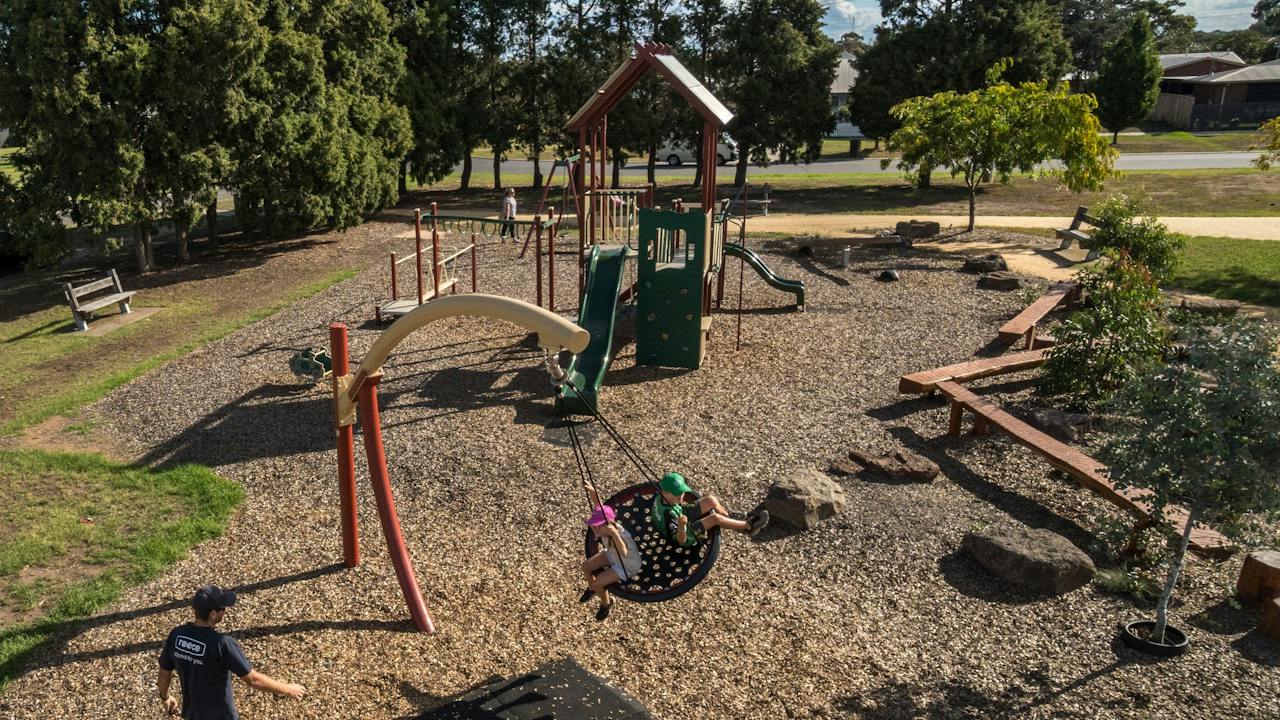
Beautifully crafted playground with lots of fun, unusual elements. Includes a large inverted V-shaped see-saw that moves on all axis, an enclosed farmyard with cow sculptures, cube climbing structure with climbing wall, hanging ladder and rope climbing frame, spiders web climbing frame, three swings, little hill with dual slides and tunnel, a doughnut-shaped object which moves around in a circle, three stand-on spinners, lamb, cow and pig springers, sandpit with mechanical scoop and a large circular path which winds to a centre with a totem pole. Shelter with barbeques, seat carved from a log and an open shelter with a table. Beautifully landscaped area around a rocky watercourse with bridge and walkway across it. There are tables, and open spaces to enjoy. Toilet facilities and river access (with steep banks, so care should be taken) are nearby.

Maffra VIC

0.7 km away

View place
Macalister Wetlands Walk
Image credit: Wellington Shire Council

Natural Attractions

Macalister Wetlands Walk

Maffra Wetlands Walk is a 2.6km lightly trafficked trail located near Maffra that features a river and is good for all skill levels. The trail is primarily used for hiking, walking, nature trips, and bird watching. The perimeter walk around the wetlands lets you take in the tranquillity of the surroundings and there is an abundance of beautiful bird life, native flora and other fauna to be viewed on this picturesque walk. With gentle hills and no steps, the track is a combination of boardwalks and gravel and is suitable for even the most inexperienced walker.

Maffra VIC

0.8 km away

View place
Victoria Park Playground

Parks and Gardens

Victoria Park Playground

Elevated wooden platform with two wave slides, tic-tac-toe, abacus and ladder. Frog and echidna springers, two stand-on spinners, pipe flowers, swings and big horizontal rope climbing frame. Some lovely wooden sculptures to explore. Huge shelter with four tables and barbeques, unshaded table, water tap and toilets. Unshaded seat and grassy areas to play.

Maffra VIC

1.0 km away

View place
Maffra Island Recreation Reserve and Skate Park

Parks and Gardens

Maffra Island Recreation Reserve and Skate Park

Whether you just want a leisurely walk, or to enjoy the sun while getting your fitness routine in, the Island Recreation Reserve in Maffra is perfect for you. It features a short one kilometre loop walk, that is an easy walk on gravel paths. It is accessible for those in wheelchairs or those with prams. For those fitness buffs, you'll also find an outdoor gym for use at the reserve. The outdoor gym features back extension, bench press, butterfly press, leg lift-dip bar, leg press, pull up, push ups, shoulder press, sit up board and stretch station. Small concrete park with a four feet deep bowl and small street area with a pyramid and some low rails and blocks. The park has a 1.2 metre deep square bowl and a street area with hubbas, rails, a triangular fun box with has rounded edges and a rail plus a separate hipped bank.

Maffra VIC

1.1 km away

View place
Maffra Sugar Beet Museum

Galleries, Museums and Collections

Maffra Sugar Beet Museum

The Maffra Sugar Beet Museum is housed primarily in the relocated office and weighbridge of the former Maffra Sugar Beet Factory, with an associated shed containing agricultural machinery. An audio-visual of Sugar Beet growing around Maffra is included, as are small exhibitions on European exploration, the Traditional Owners and pre-history. Archives and photographs are held off-site at Maffra Library. An extensive collection of Architectural plans is held. The Collection contains objects and documents relating to the cultivation of Sugar Beet around Maffra (1896-1848), and the Maffra Sugar beet factory, plus agriculture in general (especially dairy farming) and documents and photographs relating to the former Maffra Shire. Photographs include an extensive collection of the works of H.B. Hammond, a photographer at Maffra from c.1907 to the 1940s. The Maffra Sugar Beet Museum opens on the first Sunday of the month, to coincide with the monthly Maffra Market.

Maffra VIC

1.2 km away

View place
Bellbird Corner Riverside Reserve

Natural Attractions

Bellbird Corner Riverside Reserve

Bellbird Corner Riverside Reserve follows the route of a long-disused road between Sandy Creek Road and Lower Newry Road, Maffra, beside the Macalister River. The reserve contains 2.6 km of walking trails, comprised of gravel and dirt trails, that are generally flat. This trail is great for hiking, running, and walking, and it's unlikely you'll encounter many other people while exploring. Dogs are welcome, but must be on a leash. Follow the flat trail along the Macalister River and Newry Creek up to Lower Newry Road and back again. Lots of wildlife in this peaceful area.

Maffra VIC

2.2 km away

View place
Avon River
Image credit: Wellington Shire Council

Natural Attractions

Avon River

The Avon River, stretching 122 km in length, originates on the southeastern slopes of Mount Wellington, nestled beneath Miller Spur, a part of the Great Dividing Range within the Avon Wilderness Park. From its mountainous beginnings, the river flows in a meandering path, generally heading south, then east, and finally south by southeast. Along its journey, it is joined by ten tributaries, including the Turton River and the Perry River, before reaching its mouth, where it forms Lake Wellington to the east of Sale and southeast of Stratford. This river is characterized by its broad and shallow nature, boasting a width that varies from 16 to 50 meters. Such dimensions make it an accessible and welcoming destination for anglers and swimmers of all skill levels. The landscape transitions from a densely forested wilderness in its upper reaches to more open farmland as it progresses downstream. Notably, there are extensive pools along the river, some exceeding depths of 150cm, adding to the allure of this natural waterway. Beyond its appeal to fishing enthusiasts, the Avon River is celebrated for its scenic beauty. As it gracefully meanders through lush landscapes, it offers picturesque vistas that captivate nature lovers, photographers, and outdoor adventurers alike.

Stratford VIC

9.3 km away

View place
Apex Park Stratford
Image credit: Wellington Shire Council

National Parks and Reserves

Apex Park Stratford

The Apex Park in Stratford is an award-winning medieval-themed park situated on the banks of the Avon River and features a playground, an all-abilities castle adventure, BMX track, undercover barbeque areas, seating and grassed areas. The kids are sure to have a terrific time here. Facilities include public toilets, car, caravan and RV parking, sheltered area, picnic grounds, seating and a medieval themed playground. Nearby you'll also find the newly constructed Skate Park and Pump Track, which was designed with the assistance of local school children. Acclaimed Gippsland artist Ray Thomas painted a mural on the wall of the new rail bridge in Apex Park. It features the Avon River as its theme, as chosen by Stratford locals. Ray is an award-winning artist with more than three decades of experience. His works are inspired by the stories and designs of his Gunaikurnai people, as well as the Gippsland country they call home. The mural honours the Brayakaulung clan and their connection to the Avon River. It features Gunaikurnai ancestral totems and cultural practices including scarred canoe trees, stone grinding grooves and bush foods.

Stratford VIC

9.5 km away

View place
Segue Community Hub and Arts Cafe

Galleries, Museums and Collections

Segue Community Hub and Arts Cafe

Community hub and promoter of arts, tourism, community enterprises, training and community capacity building. A welcoming place a place to meet and share skills and knowledge. Segue features local artists in a wonderful rotating display of artworks. You will also find a gorgeous little cafe, gift shop and tourism information.

Stratford VIC

9.5 km away

View place
Stratford Skate Park

Sports and Recreation Facilities

Stratford Skate Park

The Stratford Skate Park consists of a concrete street course which has an open feel. One end is curved like part of a bowl and there are a few other obstacles like a side pyramid with ledge, quarter with handrail and hipped bank with ledge. There is a shelter with two tables and water tap.

Stratford VIC

9.7 km away

View place
Stratford Historical Society and Museum

Galleries, Museums and Collections

Stratford Historical Society and Museum

Housed in the former Stratford Methodist Church, an intact brick building of 1872 and the new shed, the The Stratford Historical Society and Museum collects local artefacts, documents and photographs from the area covered by the former Shire of Avon, plus Wonnangatta. Areas covered include Stratford, Munro, Stockdale, Clydebank, Bundalaguah, Nuntin, Marlay Point, Invermichie, Castleburn, Dargo, Grant, Crooked River and the other nearby alpine goldfields, including Black Snake Creek. The recent publications include local hotels, local dairy factories and the Stratford Court House. The Museum has an extensive indexing program and are a Place of Deposit for the Public Record Office. Their neighbours include the Maffra and District Historical. The Society meet at 7:30pm on the fourth Monday of the month at the Museum, Hobson Street, Stratford. The Society also meet informally and work at the Museum from 10:00am to 3:00pm every Tuesday.

Stratford VIC

10 km away

View place
A stunning sunset view from the Knob Reserve, Stratford.

Natural Attractions

The Knob Reserve

The Knob Reserve in Stratford is part of the Bataluk Cultural Trail and is an important place for the GunaiKurnai people. The reserve is set on a 56 hectare site with a lookout platform affording views over local farmlands and the Avon River. The reserve is ideal for a picnic with barbeques, tables and chairs and a playground. Migration routes used by the First People passed by what is now the Princes Highway, the Knob Reserve had sheltered campsites and was close to the river and fertile river flats that supplied plenty of good food and water and would have allowed large gatherings of clans from the GunaiKurnai nation to meet for feasting, corroborees and other ceremonies. The current Knob Reserve walk loops around the park and takes in evidence of canoe trees and sandstone outcrops that would have been used to sharpen axe heads. At the crest of the hill, an easy walk from the car park, is a lookout platform where visitors can enjoy a panoramic view across the local farmlands, the foothills and the Avon River.

Stratford VIC

12 km away

View place
Blores Hill Mountain Bike Park

Natural Attractions

Blores Hill Mountain Bike Park

Featuring an array of multipurpose cross-country trails throughout the park, Blores Hill offers 14 trails of varying difficulty levels. Pick easy, intermediate or difficult and enjoy panoramic views over the Gippsland plains on the flowing descents, bermed corners, bridges and rocky sections. Horse riders and walkers can also enjoy certain trails. This is one of the best and most beautiful mountain biking areas in Victoria. The secret's out. There are 20 kilometres of trails that include green - black trails, jumps, bridges, rocky outcrops, technical elements and flowing trails. Main access to Blores Hill is via the Weir Road from Heyfield or the Glenmaggie Tinamba Road from Sale and Maffra. Two vehicle carparks are accessible from either the Glenmaggie Tinamba Road or Ostbergs Road.

Glenmaggie VIC

15 km away

View place
Briagolong ANZAC Park

Parks and Gardens

Briagolong ANZAC Park

Within ANZAC Park lies the Briagolong War Memorial. The monument commemorates those who served in World Wars One and Two. Originally erected to commemorate those who served in World War One, two smaller obelisks were placed on either side at a later date to commemorate those who served and those who died in World War Two. A marble tablet was placed on ANZAC Day 1924 as a tribute to Mrs. Mills, who unveiled the monument, for her work with the soldiers during World War One. On the tablet are inscribed the words "Friend of the Soldiers." The memorial was officially unveiled on the 29th January 1921 by Mrs Mills in front of a large gathering.

Briagolong VIC

15 km away

View place
Gippsland Armed Forces Museum
Image credit: Wellington Shire Council

Galleries, Museums and Collections

Gippsland Armed Forces Museum

The Gippsland Armed Forces Museum aims to preserve Gippsland's military heritage, and provide the means to display and highlight the role played by Gippslanders in the country's Defence Forces, both in peace and war. It is a regional military museum that researches, educates and displays the role that Gippsland men and women of have played in the defence of Australia in times of war and peace from 1885 to the present. The collection includes military service from 1885 to now, items vary from personnel items to weapons both longarm, smallarm and bayonets, as well as items from Gallipoli, France, and Belguim. Other displays depict photographs, maps and more. Incorporated into this collection is the Aucterlonie Collection.

Fulham VIC

16 km away

View place
Flooding Creek Walk
Image credit: Wellington Shire Council

Natural Attractions

Flooding Creek Walk

Flooding Creek Walk follows the gentle flowing waterway that is known as Flooding Creek. Starting at the Cattleyard Reserve, take in the gravel pathway that mimics Flooding Creek. The walk brings you to the Water Tower, where you can then take in Pearson's Crossing that takes you over the river and leads you into the Port of Sale. The Flooding Creek Walk is a gentle walk (5.0km one way or 10km return) that takes in a gentle, gravel path. This path can be started from either the Port of Sale and finish at Woondella Estate, or in reverse.

Sale VIC

16 km away

View place
Heyfield Skate Park and Pump Track

Sports and Recreation Facilities

Heyfield Skate Park and Pump Track

The Heyfield Pump Track can be found in Apex Park next to the Heyfield Skatepark. The pump track was opened in late 2020 and is still in premium condition, looking as good as new. Since opening, the pump track has been popular with bikes, scooters, and skaters alike. The tar pump track offers significant humps and bumps to gather heaps of speed and momentum. There are a number of different loops that you can choose, catering for overtaking lanes and a variety of alternative lines. A super fun, versatile skatepark that will get people rolling around with a smile on the dial.

Heyfield VIC

16 km away

View place
Apex Park Heyfield
Image credit: Wellington Shire Council

Natural Attractions

Apex Park Heyfield

Heyfield Apex Park is a beautiful park for both kids and adults situated right in the centre of Heyfield. Recently redeveloped the park has a magnifcent playground complete with wooden treehouse, giant swing, bouncy truck and australian animal wood sculptures. Many picnic tables are scattered amongst the trees and gardens, a dry creek bed meanders through the centre of the park and undercover free electric barbeques and toilet facilities are all available. For those wishing to take a stroll the Rail Trail passes right by and continues on past the Skate Park, the Migrant walk and on to the Lions Club Rotunda and Memorial Rose Garden. The perfect spot to take a break, let the kids release some energy, refresh and enjoy a relaxing lunch.

Heyfield VIC

17 km away

View place
Heyfield Wetlands

Natural Attractions

Heyfield Wetlands

The Heyfield Wetlands is a beautiful focal point for Heyfield and situated at the Wetlands overlooking a small lake is the Information Centre. For the public's enjoyment, four kilometres of walkways with eight exercise stations and boardwalks have been built on the twenty eight hectare reserve. The Wetlands offers a place for people to enjoy walking, exercising, bird watching, fishing, photography and outdoor events. Sitting beside the Information Centre is a barbeque, shelter and wheelchair-friendly picnic table for general use. The Information Centre is run by volunteers and can provide brochures, maps and booklets on what is available to see and do in the area. A lovely variety of local art and craft can also be purchased and at various times the centre is hired out for private functions with an electronic whiteboard available for use. Events hosted at the centre have included parties, weddings, funerals, conferences, meetings, craft groups, exhibitions and concerts. The Wetlands committee provides catering for functions on request. Please contact us for costing of hire and catering or pop in to say hello and have a look around.

Heyfield VIC

17 km away

View place
Brennan Park

Sports and Recreation Facilities

Brennan Park

Located close to the heart of Sale, Brennan Park has landscaped entry areas, rotunda with a barbeque, a play area, basketball court and running track. The large grass area remains central to the park. Playground features a structure with wave slide, climbing wall, shop front, rope bridge, steering wheel, fireman's pole, curved walk way, little wave slide, clock, steps, monkey rungs and balance beam with obstacles. Also swings and toad springer.

Sale VIC

18 km away

View place
Herb Guyatt Sanctuary Reserve

National Parks and Reserves

Herb Guyatt Sanctuary Reserve

This sanctuary is named after Herb Guyatt who was one of the first environmentalists in the Sale region who advocated for the protections of local wetlands. This walking track takes you into the hidden natural beauty which is comprised of a series of billabongs which were originally a horseshoe bend in the Thomson River. The area has become a haven for a wide variety of birds and there are many to be seen on your travels. The Herb Guyatt reserve is accessible by car at Riverview Road, from Sale head along the Princes Highway towards Melbourne, at the second roundabout take a right onto Fisk Street, then right at Wurruk Way this will follow around onto Riverview Road. To access on foot, from Sale follow the footpath out to Pearson’s Crossing then turn right into Riverview Road at the signposts. The walking track though only a shorter walk, takes you into the hidden natural beauty of the Herb Guyatt Sanctuary. The sanctuary is comprised of a series of billabongs, which were originally a horseshoe bend in the Thompson River.

Wurruk VIC

18 km away

View place
Avon Mt Hedrick Scenic Reserve

Natural Attractions

Avon Mt Hedrick Scenic Reserve

Avon-Mt Hedrick Natural Features and Scenic Reserve is three hours drive east of Melbourne, near Maffra in the foothills of the Victorian Alps. The Avon River winds majestically through the 5700 hectare reserve, over time sculpting beautiful gorges from the surrounding landscape. The dry open forest has a diversity of wildflowers as well as rocky escarpments and several high peaks with sweeping views of the surrounding area. The Channels is the centrepiece of the reserve; a magnificent gorge created by the Avon River. The steep sides of the gorge are covered in native vegetation. Crags punctuate the riverbed, creating a system of pools and rapids that provide important habitat for aquatic life. The reserve offers camping, picnicking, scenic lookouts, walks of various lengths, sightseeing, horse-riding, fishing, swimming and car touring.

Boisdale VIC

19 km away

View place
Victoria Park Sale

Parks and Gardens

Victoria Park Sale

Victoria Park offers open spaces, green grass and a whole lot of history. Once the Market Square, Victoria Park became integral to early life in Sale. You'll find easy walking paths that take in the historic water towers (one a large brick tower that has been converted into a museum space, that was constructed in 1887 and a smaller concrete tower in 1922). A bandstand rotunda was also constructed in 1913 to celebrate the Jubilee of Sale. It was dismantled in 1976 and reconstructed in 1980-83. The park features lovely shady areas with seating dotted around the grounds, with a watering hole and sculptures also to be found on your walk.

Sale VIC

19 km away

View place
Port of Sale - Wellington Centre
Image credit: Wellington Shire Council

Galleries, Museums and Collections

Port of Sale - Wellington Centre

A significant redevelopment was undertaken in 2004 which saw the precinct reinvigorated to include entertainment, art, heritage and leisure facilities. The development of extensive berthing/mooring facilities, a boardwalk, barbeque/picnic locations and walking paths saw the Port revitalised - and become increasingly popular with both tourists and locals alike. This Centre presently houses the Sale Library, Gippsland Art Gallery, Sale Visitor Centre, Council Chambers, café and community spaces. East of the Centre, the Borun and Tuk Aboriginal cultural walk was created, providing pedestrian access from Foster Street to the Port itself. The path includes lighting, landscaping and culturally significant canoe seating, whilst also telling the Gunaikurnai creation story of Borun the pelican and Tuk the musk duck. West of the Centre, the Sale Skate Park received a significant facelift and expansion to become one of the best skate facilities east of Melbourne. This area also includes a multi-court facility, barbeque shelter and an all-ages play space. Visually attractive and informative signage, combined with paving and landscaping seamlessly link all aspects of the precinct together. Today, the Port Precinct is regarded as Sale's cultural and entertainment hub and is considered one of Gippsland's must-visit tourism locations.

Sale VIC

19 km away

View place

What is happening now?

Search dated events, markets, live music, sport and community activities.

Explore Events

Planning by place?

Use Things to Do for attractions and experiences that are not tied to one event date.