Places worth discovering

Things to Do

Find attractions, experiences and places to visit. Events remain the best way to see what is happening on a particular date.

Looking for a dated event? Explore Events

35 places

Explore local places

Nungarin Heritage Machinery and Army Museum
Image credit: Image from operators website

Galleries, Museums and Collections

Nungarin Heritage Machinery and Army Museum

Between 1942 and 1962 Nungarin was a depot for Australian army personnel, supplies and machinery. The Nungarin Heritage Machinery and Army Museum is situated in the original Army Vehicle Workshop which was constructed between 1942 and 1943 as part of Australia's defence in WWII. During the war, there was a limited supply of tractors. After the war, most of the facilities and buildings were sold, with the Nungarin Shire purchasing the Army Vehicle Workshop for use as a Shire Depot. Tanks like the 1942 Stuart Tank, were sold and used for clearing farms. The museum holds an impressive collection of army tanks, trucks, vehicles and farm machinery. Look out for the "Mad Max of vehicles" - the 1942 Dingo Scout Car. There is also a display of army uniforms, badges, small armoury, electronics and photographs. and the impressive 10th Light Horse Collection dedicated to Trooper Joseph William Spillman (a veteran of the Gallipoli and Palestine campaigns, and one of only 15 light horsemen to have been awarded the Military Medal). Don't forget to visit Marie "Aunty Jim" Farrell's shop. The contents of her shop were donated to the Museum when she retired in 2000. It includes a kitchen and dining area and of course the kitchen sink!

Nungarin WA

0.4 km away

View place
Talgomine Rock
Image credit: Shire of Merredin

National Parks and Reserves

Talgomine Reserve

The colourful display of everlastings in Talgomine Reserve, just east of Nungarin, is a spectacular sight. Enjoy a stroll through the endless fields of pink and yellow everlastings which bloom in abundance during spring. Nature lovers will appreciate the York Gum and Jam Tree woodlands within the reserve, home to a variety of orchids and other wildflower species that thrive in the area. Relax in this tranquil setting to enjoy a picnic and soak up the rural ambience. Take a stroll along the walking trail to discover more of Talgomine and climb Mount Moore for scenic views across the reserve and out to Lake Campion, an inland lake. Keep an eye out for the many native animals and birdlife that inhabit the area. If time permits take the short 15-minute drive to Lake Campion to get up close to the abundant bird life and enjoy a refreshing swim or canoe across the huge expanse of water. Talgomine Reserve is a three and a half hour drive east of Perth and a short drive from the regional town of Nungarin.

Nungarin WA

22 km away

View place
Wheatbelt Way Self Drive Trail

Historical Sites and Heritage Locations

Wheatbelt Way Self Drive Trail

The Wheatbelt Way self-drive trail will lead visitors on an adventurous interpretive journey to the regional communities of Dowerin, Wyalkatchem, Koorda, Bencubbin, Beacon, Westonia, Mukinbudin, Nungarin and Trayning. Experience their natural attractions, history and heritage while offering unique opportunities to stay and experience friendly communities and open landscapes. Duration: 3-5 days or more Distance: Approximately 900km-1,000km Road Conditions: Sealed road with stretches of good unsealed road to rock and bushland features. Wondering where to stay? There are excellent caravan parks available in most towns, Country Hotels, Bed and Breakfasts or why not camp out under the stars at our free camping areas. The Wheatbelt Way self-drive trail highlights 24 unique sites ranging from natural attractions to sites of historical importance. Enjoy the 12 free campsites along the Wheatbelt Way. There will be many opportunities to stay and experience the best the Northern Wheatbelt has to offer. To ensure you enjoy a safe and well-planned journey, carefully look into the estimated travel times and distances, this is just a guide to get you started! Enjoy the unique charm of the Wheatbelt Way where you can experience good old-fashioned hospitality while exploring at your own leisure. For more information visit the website.

Mukinbudin WA

32 km away

View place
Pergandes Sheepyards
Image credit: Shire of Mt Marshall

Historical Sites and Heritage Locations

Pergandes Sheepyards

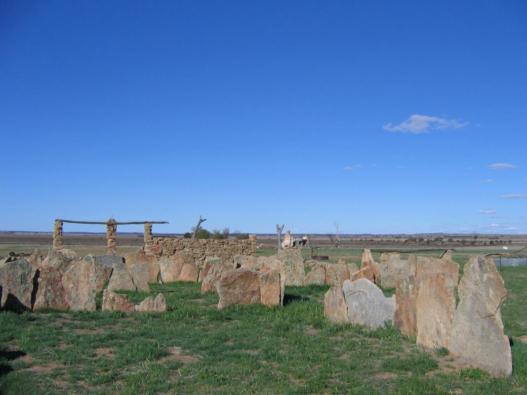
On the drive between Bencubbin and Mukinbudin is the intriguing and unusual sight of the Pergandes Sheepyards. The town of Bencubbin is just a three and a half hour drive northeast of Perth. Located at the site are the remains of an original and prominent homestead and sheep yards that were constructed almost entirely from local granite. The sheep yards are made from large granite slabs that were drawn into position by horse sled from the nearby Wiacubbing Hill. These slabs were then placed upright out of the ground to make the fences of the sheep yards. The homestead was constructed using smaller round rocks held together by mortar. Just a few minutes along the road you will find Marshall Rock, where you will be rewarded with a panoramic view across the Wheatbelt. This area is renowned for its extensive display of wildflowers.

Bencubbin WA

32 km away

View place
Merredin Silo Art
Image credit: Michael Fudge

Landmarks and Buildings

Co-operative Bulk Handling (CBH) Wheat Storage and Transfer Depot

The Co-operative Bulk Handling Wheat Storage and Transfer Depot is the largest inland port in Western Australia. The sheer enormity of the depot is an impressive sight to see and is well worth capturing on camera. Learn about the significant impact the depot has had on the economic development of Merredin with a visit to the Central Wheatbelt Visitor Centre. The depot has been in operation since 1966 with the largest storage bin measuring 610 metres in length and 59 metres in height with storage capacity of 600,000 . This grain storage bin is the largest in the southern hemisphere, with total storage capacity of 1,062,200 tonnes. In August 2017 the Merredin Silos were transformed by Western Australian street artist Kyle Hughes-Odgers to complete artworks across four 35-metre high silos. The carefully researched artwork concept tells a story about Merredin, its natural environment in the colours, its diverse community in the artwork's abstract forms and figures, and its landforms and agricultural history in the symbols. Merredin is the largest regional town in the Central Eastern Wheatbelt and it is a three hour drive east of Perth. It is home to many charming historic buildings including the town hall and Cummins Theatre. Enjoy a 75-minute walk along the Merredin Peak Heritage Trail for magnificent views of the surrounding countryside.

Merredin WA

37 km away

View place
Long Tan Memorial Merredin
Image credit: Shire of Merredin

Parks and Gardens

Roy Little Park Merredin

This large open reserve is ideal for weddings and open air functions. The park is located adjacent to King Street (behind the Shire office) and has a large central water feature. Ducks and other water birds inhabit this popular family area. A prominent feature in Roy Little Park is the Vietnam Veterans Reflection Pond Memorial – an attractive and purposeful place to sit and reflect on the servicemen and women who have heroically defended the country. Wheelchair and mobility scooter access. Dogs permitted on leash.

Merredin WA

37 km away

View place
Merredin Council Mosaic
Image credit: Central Wheatbelt Visitor Centre

Landmarks and Buildings

Council Office Mosaic

The Council Office Mosaic in Merredin is a beautiful mosaic artwork which was designed by local artist Ann Sutherland. The design was selected to represent the Wheatbelt as part of the prominent water feature which is displayed adjacent to the Bell Tower in the centre of Perth. The Council Office Mosaic sits strikingly amidst a rock garden outside of the council offices in the town of Merredin. It is a unique artistic interpretation of the region and the water trickling across its surface creates a lovely cooling effect. It is a pleasant spot to stop and stretch your legs on arrival in Merredin. The regional town of Merredin is a three-hour drive east of Perth. Whilst in the area take a drive along the Merredin Peak Heritage Trail or follow the Heritage Walk around town. Grab a trail map at the Central Wheatbelt Visitor Centre. Enjoy the magnificent views of the countryside from the peak, which are made even more spectacular during the wildflower season.

Merredin WA

37 km away

View place
Mititary Hanger Merredin
Image credit: Shire of Merredin

Historical Sites and Heritage Locations

World War II Sites - Merredin

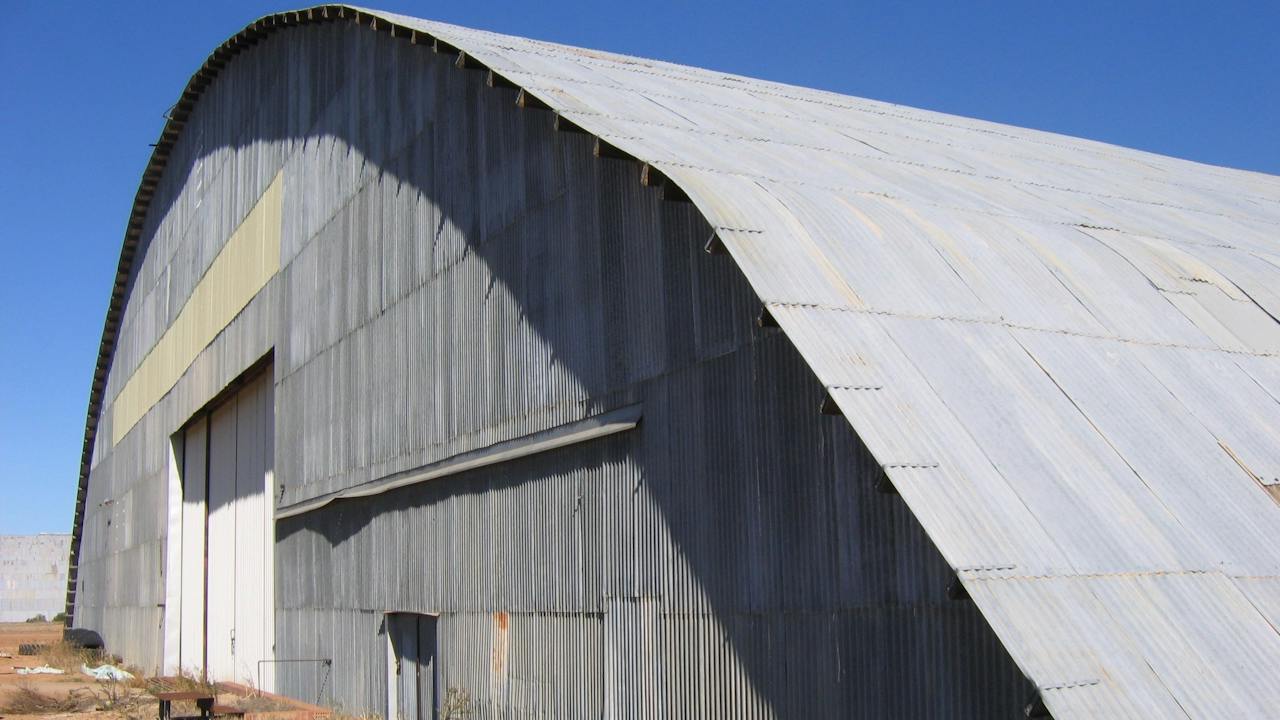
The World War II Sites in Merredin provide a fascinating insight into the role the Central Wheatbelt played in Australia's preparation for World War II. Visit the old hangars and the Officer's mess which together tell an interesting part of the town's history. Military history enthusiasts will be captivated by the RAAF No 10 Store Depot which comprises of igloo-shaped tin hangars. They were originally built in 1943 to store American aircraft for the war. From the sky, the hangars were camouflaged to look like a salt lake. Take a drive to the High Frequency Direction Finding Installation, also known as the Radar Hut. It was built to give advance warning of an impending invasion. Whilst it is on what is now private property, it can be seen from the Merredin-Chandler Road. Grab a copy of the Merredin brochure and follow the Military Site Drive Trail taking in the sites around Merredin, approximately 90 kilometres return. The country town of Merredin is a three hour drive north east of Perth. A visit to the Australian General Army Hospital and the nearby Military Museum will complete your World War II tour of Merredin.

Merredin WA

37 km away

View place
Cummins Theatre, Merredin
Image credit: Shire of Merredin

Entertainment Venues

Cummins Theatre

This heritage-listed theatre on Bates Street has been a proud fixture in Merredin's cultural history since it was relocated from Coolgardie in 1927. Originally for film screening, Cummins Theatre was one of the first venues to show "talking" pictures in the Commonwealth and for many years was considered state of the art in its field. The theatre owes its existence in Merredin to James Cummins, who was the Mayor of Kalgoorlie and owner of both the Merredin and Kalgoorlie breweries. Mr Cummins purchased the Tivoli Theatre, which had been built in Coolgardie in 1897, and had it dismantled and sent in pieces to Merredin by train. Here, the thirty-year-old theatre was rebuilt where it stands today on Bates Street. Renamed in honour of its founder, Cummins Theatre opened to the public on 10 October 1928. Cummins Theatre had extensive conservation work completed in September 2010 and now holds a wide variety of touring productions, and theatrical and musical performances. Tours of the venue are also available.

Merredin WA

37 km away

View place
Merredin Town Hall
Image credit: Shire of Merredin

Historical Sites and Heritage Locations

Merredin Town Hall

The charming Merredin Town Hall was built in 1925 as a memorial to the soldiers who lost their lives in World War I. Take a walk around this aesthetically pleasing building which photographs beautifully from every angle. Examine the clock tower which contains a small replica of the clock face of Big Ben at Westminster in London. Explore the town's other historic buildings of significance, including the post office and the Cummins Theatre. The theatre was built from remnants of demolished buildings in Coolgardie including a theatre and pubs. Legend has it that the bricks contain small amounts of gold. Take a drive along the Merredin Peak Heritage Trail or for the more energetic there are walk trails available. Enjoy the magnificent views of the countryside from the peak, which is even more spectacular during the wildflower season. Stop in at the Merredin Visitor’s Centre for trail guides and learn about the town's history. The farming town of Merredin is a three-hour drive east of Perth.

Merredin WA

37 km away

View place
Merredin Water Tower
Image credit: Central Wheatbelt Visitor Centre

Historical Sites and Heritage Locations

Merredin Railway Water Tower

The Merredin Railway Water Tower is a 15-metre-high tower that guides visitors into the rural town of Merredin. Located in Pioneer Park, the 1893 tower held the water that was used to operate steam locomotives for more than 60 years. Visit the Military museum next to the tower to see Western Australia’s largest collection of military vehicles and equipment. Head back into the town centre to discover the fascinating Merredin Railway Museum. Step back in time in this beautifully restored station and envisage life in the 1890s. Containing an extensive collection of railway memorabilia including a beautifully preserved 1897 steam engine, the museum will appeal to all train enthusiasts. Merredin is also home to several other charming historic buildings including the town hall and Cummins Theatre. Take a walk around the town admiring the streetscapes. Alternatively, enjoy a 75-minute walk along the Merredin Peak Heritage Trail for magnificent views of the countryside. The farming town of Merredin is a three-hour drive east of Perth.

Merredin WA

37 km away

View place
Merredin Peak
Image credit: Shire of Merredin

Natural Attractions

Merredin Peak Trail

The Merredin Peak Trail provides an uninterrupted view across the town of Merredin and the surrounding rural area. As the highest peak in the area, it offers spectacular panoramic views as far as the eye can see. Choose between two walk trails, depending on your level of fitness and stop to read the informative plaques indicating various points of interest along the trail. The moderate slope will take you about 30 minutes, whilst the steeper more challenging slope will appeal to regular hikers and will take about 1 hour to complete. Much of the walk is across a rocky surface which can become slippery and there is minimal shade. It is advisable that you wear suitable walking shoes, sun cream and a hat and ensure you carry sufficient water. Stop in at the visitor centre to collect a map of the trail and learn more about the other attractions in the area. Merredin Peak is also a 72-hour site for fully self-contained RVs. No fires, dogs permitted off leash. The Merredin Peak Trail is one of many recommended stops along the Golden Pipeline Heritage Trail. Merredin is the largest regional town in the Central Eastern Wheatbelt and is a three-hour drive east of Perth.

Merredin WA

37 km away

View place
Cummins Theatre Merredin

Galleries, Museums and Collections

Merredin Heritage Walk

The Merredin Heritage Walk begins in the Museum precinct where you can see the Railway, Military Museums and historic water tower. Continue along the trail through Barrack and Mitchell Streets and see the Merredin Courthouse, Town Hall and Cummins Theatre. Take a look inside Cummins Theatre and see the beautiful pressed tin ceiling. Take a look at the former bank buildings and see what they are used for today. Continue along the trail to the Long Tan Vietnam Memorial then continue back towards the visitor centre where the trail ends. Trail maps are available from the Central Wheatbelt Visitor Centre collect an A3 Merredin Map containing the Heritage Walk.

Merredin WA

37 km away

View place
Merredin Military Museum
Image credit: Central Wheatbelt Visitor Centre

Galleries, Museums and Collections

Merredin Military Museum

The Military Museum in the town of Merredin houses Western Australia's largest collection of restored military vehicles and equipment. Stroll around the museum to examine the vehicles that were used by the Australian Armed Forces during the two World Wars, as well as the Korean and Vietnam wars. Several vehicles are still in working order and have been proudly restored to their original state. View the masks and uniforms worn by the soldiers and the weaponry used to win many battles. Purchase a detailed booklet at the museum about the extensive collection and various World War II sites and attractions within Merredin including the World War II hangars and Army General Hospital site. Merredin is the largest regional town in the Central Eastern Wheatbelt and is a three-hour drive east of Perth. Various walking trails within Merredin and the surrounding region offer an opportunity to discover the magnificent countryside and several historic sites along the way.

Merredin WA

37 km away

View place
FORM's PUBLIC Silo Trail: Merredin

Landmarks and Buildings

FORM's PUBLIC Silo Trail: Merredin

The third completed PUBLIC Silo Trail mural in regional Western Australia is a 35-metre high artwork created in August 2017 by Perth artist, Kyle Hughes-Odgers’ in Western Australia’s central Wheatbelt town of Merredin. The mural joins silo artworks in Northam and Ravensthorpe which together form a self-drive trail for tourists and travellers to take through regional Western Australia casting a spotlight on less-known towns. Creating the artwork was a labour of love, requiring the artist to work around the clock. Through his geometric yet playful paintings on the Merredin silos, Hughes-Odgers depicts two large plant pots with sprouting seedlings which represent the importance of the agricultural industry to Merredin and the Wheatbelt region. A man and a woman are standing tall on the silos. The patterns on the woman’s body pay reference to local buildings, structures and local icons in Merredin. The designs on the man’s body are inspired by local salt lakes, dams, and granite outcrops. The colours are recognisable, as they are taken directly from the Wheatbelt’s natural environment. The burnt oranges, yellows, and blues are from the landscape and sky.

Merredin WA

38 km away

View place
Horse Watering Trough Merredin
Image credit: Central Wheatbelt Visitor Centre

Landmarks and Buildings

Hitching Rail and Horse Watering Trough

Within the centre of the charming town of Merredin, you will find the Hitching Rail and Horse Watering Trough. Relax under the shade of the large native trees within the park and read the informative plaques to learn the history and get a greater appreciation of these fascinating attractions. Horses used to be tied to the 1920s Hitching Rail and would drink from the old water trough when the locals came into the town centre. These sites form part of the Merredin Heritage Walk trail - a one-and-a-half kilometre walk around Merredin town centre. Grab a map from the Central Wheatbelt Visitor Centre, located at Merredin Train Station on Barrack Street. Merredin is the largest regional town in the Central Eastern Wheatbelt and is a three-hour drive east of Perth. During your visit make time to enjoy a drive along the Merredin Peak Heritage Trail or take a stroll along one of the walk trails on offer which are even more spectacular during the wildflower season.

Merredin WA

38 km away

View place
Merredin Army General Hospital Site
Image credit: Australia's Golden Outback

Historical Sites and Heritage Locations

Army General Hospital Site

The foundations of a once-active hospital are all that remain at the Merredin Army Hospital Site. Wander over the concrete base and imagine the scene with army medics racing around to help injured soldiers during World War II. The hospital was situated in Gaza Ridge near Tobruck and was relocated here in 1942. Read about the hospital's history and the significant role it played in the war, and discover why it was relocated to Merredin. Then take a walk to the Military Museum in the town centre to view various fascinating artefacts and memorabilia. The museum is now home to the hospital relics. Merredin is the largest regional town in the Central Eastern Wheatbelt and is a three-hour drive east of Perth. It is home to many charming historic buildings including the town hall and Cummins Theatre. Enjoy a 75-minute walk along the Merredin Peak Heritage Trail for magnificent views of the countryside and townsite.

Merredin WA

38 km away

View place
Merredin Railway Museum
Image credit: Shire of Merredin

Galleries, Museums and Collections

Merredin Railway Museum

The Merredin Railway Museum pays tribute to the days of steam with a well-restored recreation of the old station. You can pretend to drive a steam train and climb the signal tower for an interesting outlook. It is a real highlight for railway enthusiasts. Appreciate the architecture of the Railway Museum buildings dating back to 1913, with much of the original railway memorabilia still in place. Merredin was once a major rail junction for the Central Wheatbelt. Displays include; a G117 class steam locomotive circa 1897, a signal box housing 95 levers, displays of Merredin's railway history and a photographic register of pioneer women of the area It is set amidst an attractive garden setting where you can feed goldfish in the ponds. Merredin is located three hours east of Perth. The township of Merredin has a number of interesting and unusual historic buildings worth visiting including the Post Office (1913), the Town Hall (1925) and the Cummins Theatre.

Merredin WA

38 km away

View place
Tamma Parkland
Image credit: Central Wheatbelt Visitor Centre

Parks and Gardens

Tamma Parkland

Tamma Parkland provides a glimpse into the type of vegetation that was once found in the area. The 23 hectares is home to 175 native plants in five habitat sites. More than 45 species of birds have been sighted in the park and there are two species of trap door spider. In springtime droseras, a variety of orchids, grevillea, hakea and the mallee trees are all a feature of the park. A popular spot to explore during wildflower season Tamma Parkland is located on the southern side of the Merredin townsite.

Merredin WA

38 km away

View place
Marshall Rock

Natural Attractions

Marshall Rock

Marshall Rock is eight kilometres from the town of Bencubbin. Take a few sausages out with you to cook on the barbecues provided, and enjoy the spectacular views of the surrounding district. The picnic area provides a lovely relaxed atmosphere with a wide variety of native flora and fauna. Marshall Rock was discovered in 1836 and provides a 360-degree view of the surrounding countryside including; Lake McDermott, Bencubbin, Welbungin and Wiacubbing Hill. Bencubbin is a three-and-a-half-hour drive northeast of Perth and is located in the centre of the Wheatbelt. Take time to appreciate the abundance of beautiful wildflowers and bird life in the area. The wildflower season runs from June to October.

Bencubbin WA

42 km away

View place
Totadgin Conservation Park
Image credit: Shire of Merredin

National Parks and Reserves

Totadgin Conservation Park

Totadgin Conservation Park offers a picturesque setting for a picnic and provides an ideal location to discover much of the native flora and fauna inhabiting the area. Take a gentle stroll along the bottom of the Totadgin Rock, which is a granite outcrop with a similar wave formation to the more famous Wave Rock in Hyden. Discover the plethora of native birds that live in the reserve, including the White-eared Honeyeater and Chestnut-rumped Thornbill. Relax at the picnic area under the shade of the woodlands and enjoy a barbecue lunch before continuing on to explore more of the reserve. A visit to the reserve in spring is even more spectacular with the diverse assortment of wildflowers out on display. Totadgin is located 14 kilometres or just ten minute's drive south of the Central Wheatbelt town of Merredin which is three hour's drive north east of Perth. Discover more of the surroundings by taking the 75-minute walk along the Merredin Peak Heritage Trail and taking in the superb views along the way.

Merredin WA

44 km away

View place
Wattoning Historical Site

Historical Sites and Heritage Locations

Wattoning Historical Site

The Wattoning gnamma hole was an important water site for Aborigines. In the late 1800's two rock lined wells and a soak were constructed by early pastoralists and precious water was carted from these by pastoralists, sandalwood cutters and prospectors. A homestead was constructed in 1873 by James Ward who lived here until about 1890 when it was then inhabited by the Ives Family and then later still by the Hall Family. Both families lost children who are buried in the small graveyard alongside an earlier pioneer. The homestead was then vacant after the tragic death of Mr Hall's child. The vacant homestead was then used as a camp by Sandalwooders, who would pull wood in the bush and bring it back to Wattoning for cutting and cleaning. Wattoning homestead was burnt down sometime after 1911. At the homestead site there is a picnic table and signage describing life at Wattoning in the early days. There are also the remains of a soak and two wells. The Wattoning Historical Site is located near Elachbutting Rock. While in the area pay a visit to this granite outcrop which has eroded into a spectacular wave-like formation over many thousands of years. Wattoning is near the town of Mukinbudin and is a four hour drive east of Perth.

Mukinbudin WA

48 km away

View place
Collgar Wind Farm
Image credit: Central Wheatbelt Visitor Centre

Agritourism

Collgar Wind Farm Merredin

Located 25 kilometres southeast of Merredin the Collgar Wind Farm covers 18,000 hectares and contains 111 turbines which generate enough power to supply 136,000 homes. It is the largest wind farm in Western Australia by installed capacity. The project location was selected for its unique topography, world class wind resource, favourable community rapport and proximity to the power grid. Wind power provides a natural, renewable source of energy and is playing an increasing role in reducing global greenhouse gas emissions. Collgar Wind Farmis operated by Collgar Renewables, a leader in the operation of renewable energy projects. Visitors are invited to stop at the interpretative information shelter located on Bulls Head Road.

Norpa WA

52 km away

View place
St Lukes Church Westonia

Historical Sites and Heritage Locations

St Lukes Anglican Church

St Lukes Anglican Church in Westonia is a restored weatherboard church, which was originally erected at Naretha over 600 kilometres to the east. Its' original purpose was to serve workers on the construction of the trans-Australian railway in 1916. Built by Joseph Budge, a missionary from the Navy Mission Society, it was dismantled, moved to Westonia and rebuilt after the completion of the line in 1918. It was a fairly common practice at that time to transfer structures to a new site when they ceased to be useful in their existing site. Take some time to appreciate the amazing feat of relocating the church overland for such a distance, back in the early 1900s. This simple historic building is constructed of weatherboard with an iron roof; it was later lined with wallboard. St Lukes Church is a 48-hour free camping site for fully self-contained recreational vehicles only. Westonia is a four-hour drive east of Perth, it is a tiny settlement of 250 people, which was formerly a mining boom town and now services the surrounding wheat and sheep area.

Westonia WA

58 km away

View place

What is happening now?

Search dated events, markets, live music, sport and community activities.

Explore Events

Planning by place?

Use Things to Do for attractions and experiences that are not tied to one event date.